Approximate Location Map
Large Map »
Latitude: 52.2706 / 52°16'14"N
Longitude: 0.3293 / 0°19'45"E
OS Eastings: 559029
OS Northings: 266165
OS Grid: TL590661
Mapcode National: GBR N9G.L2D
Mapcode Global: VHHK0.N6F5
Plus Code: 9F4278CH+7P
Entry Name: Dovecote to East of Number 28 (Crowland Farmhouse)
Listing Date: 31 January 1984
Grade: II
Source: Historic England
Source ID: 1126399
English Heritage Legacy ID: 48945
ID on this website: 101126399
Location: Old Pembroke Farm, East Cambridgeshire, CB25
County: Cambridgeshire
District: East Cambridgeshire
Civil Parish: Burwell
Built-Up Area: Burwell
Traditional County: Cambridgeshire
Lieutenancy Area (Ceremonial County): Cambridgeshire
Church of England Parish: Burwell with Reach
Church of England Diocese: Ely
Tagged with: Dovecote
TL 5866 TL 5966 BURWELL HIGH STREET
(East Side)
15/17 16/17 Dovecote to East
of No 28
(Crowland
Farmhouse)
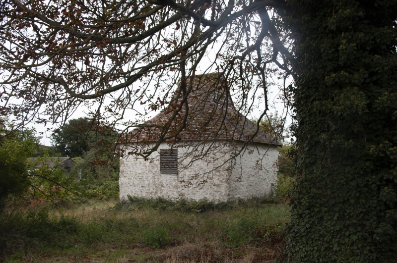
GV II
Dovecote, early C19. Clunch with hipped plain tile roof and
gablet flight entry boarded over. Square plan with boarded
entrance door in segmental arch facing west. Six hundred and
fifty clay-bat pigeon holes with limestone ledges.
Jeevar P. Dovecotes of Cambridgeshire, p.16, 1977
RCHM, North-East Cambs, p.30, p.lii, mon. 22
Listing NGR: TL5902966165
External links are from the relevant listing authority and, where applicable, Wikidata. Wikidata IDs may be related buildings as well as this specific building. If you want to add or update a link, you will need to do so by editing the Wikidata entry.


Other nearby listed buildings
