Latitude: 52.3981 / 52°23'53"N
Longitude: 0.2531 / 0°15'10"E
OS Eastings: 553388
OS Northings: 280176
OS Grid: TL533801
Mapcode National: GBR M6G.QSD
Mapcode Global: VHHJ6.BZMH
Plus Code: 9F4297X3+66
Entry Name: Barn to south-west of St John's Farmhouse
Listing Date: 23 September 1950
Last Amended: 13 December 2017
Grade: I
Source: Historic England
Source ID: 1126456
English Heritage Legacy ID: 48781
ID on this website: 101126456
Location: Ely, East Cambridgeshire, CB6
County: Cambridgeshire
District: East Cambridgeshire
Civil Parish: Ely
Built-Up Area: Ely
Traditional County: Cambridgeshire
Lieutenancy Area (Ceremonial County): Cambridgeshire
Church of England Parish: Ely
Church of England Diocese: Ely
Tagged with: Barn
Traditionally described as a chapel, although its original purpose and relationship to the hospitals of St John or St Mary Magdelene is not fully understood. It lies within the historic curtilage of St Mary’s, but contains early-C13 fabric, apparently predating the merger of the two hospitals.
Stone barn, traditionally described as a Chapel, C13 in origin with later remodelling.
Materials: built of stone rubble, with dressed-stone detailing and a clay-tile hipped roof.
Plan: the building is rectangular in plan.
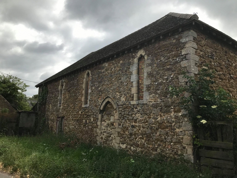
Exterior: the building is of four bays. The north elevation fronts on to St John’s Road with four regularly spaced narrow lancet openings at a relatively high level with moulded stone surrounds, all blocked with brick. The upper points of the lancet openings sit just below the level of the top of the wall suggesting the side walls have been lowered from their original height. Towards the west of the elevation is a large, blocked doorway with stone jambs and a two-centred arched head. The doorway has a simple chamfered outer edge and a hood mould above. Set above the hoodmould is a stone carving depicting the figure of a man astride a beast flourishing a horn. Stylistically this is difficult to date because it is so worn but has been interpreted as C9 or C12 in date. If of the C12, it is possible it relates to an earlier hospital building, perhaps an original foundation of one of the hospitals, the precise dates of which are unknown. A later door has been added further to the east.
The south elevation has again been heavily altered, but has parts of two window openings surviving in the corresponding positions to the outer window openings on the north elevation. These appear to have been of the same form as those to the north and originally the elevation may have had the same arrangement of four. It certainly had a doorway in the corresponding position as that on the north elevation, i.e towards the western end. The elevation contains a full height cart door (a later insertion) immediately to the west of which is one of the high level windows. Further to the west is an original opening, similar to and opposite the entrance from the north. The west elevation had a single, high level window, its presumed arch truncated by the later roof. The east elevation is the most heavily altered, of which the outer jambs of what are thought to be either two separate window openings placed towards the outer edge of the elevation or a larger single window survive. They sit at approximately the same height as the single opening in the western elevation, and similarly appear to have been truncated with the loss of their arched heads, which again would suggest a gabled eastern elevation.
The truncation of the walling indicates the roof has been replaced and that the building was gabled.
Interior: the features described from the exterior are all identifiable on the interior with most doors and windows having splayed reveals on the interior. The base of the east elevation window openings corresponds internally to a simple, moulded string course formed of a single roll. This terminates on both sides at the outer edges of the window opening, although this is probably due to later truncation, and it may originally have run across the elevation. It does not appear to have returned on either of the side walls, and may have been intended to provide some architectural emphasis to the east end of the building.
The building was evidently lit from all four sides indicating it was not part of a wider range, although it could have had lower structures attached to it. The height of the door openings suggest it always functioned as a single space, open to its roof, relatively self-contained and almost certainly the principal structure of the complex. The internal roof structure is a modern replacement.
The present farm of St John’s, Ely occupies the site of a medieval hospital, institutions established to care for the infirm poor (and also other groups of people in need) from the early middle ages until the dissolution of the monasteries in the C16. Typically, they formed a group of buildings housing a religious or secular institution which provided both spiritual and medical care. The idea for such institutions originated in the Anglo-Saxon period, although the first definite foundations were created by Anglo-Norman bishops and queens in the C11. Documentary sources indicate that by the mid-C16 there may have been about 1000 foundations in existence, most of which were run by a religious community headed by a prior or master. Half of the hospitals present at that time were suppressed as part of the Dissolution of the Monasteries in 1539. Some smaller institutions survived until 1547, when they were dissolved by Edward VI, but others continued in use as almshouses.
Buildings of hospital complexes tended to adopt a monastic form, with a similar range of buildings, but with the nave or body of the church containing the infirmary hall and its inmates, their beds placed in the aisles. The chapel itself was generally confined to the east end of the building, often a single cell, perhaps with a sacristy attached. Other ranges included cloisters, refectory and dormitory, accommodation for the master and guests, as well as service buildings, depending on the size of the hospital. The complex as a whole would have been surrounded by a wall or earthwork enclosure.
The present farm known as St John’s is thought to occupy the site of the Hospital of St Mary Magdelene, first recorded in 1225 when it was gifted the church at Littleport. In about 1251 this hospital was merged with a second, St John the Baptist, by Bishop Hugh Northwold. It then became the Hospital of St John the Baptist and St Mary Magdelene. The bishop also drew up a simple rule for communal living: the hospital was to be placed under the care of a Master, and was to have no more than 13 brethren, both lay and clerical. The Master was allowed a room of his own, but all others were to share a single dormitory, and all, including the Master, were to eat together in one refectory.
Specific hospital buildings mentioned in Bishop Fordham’s revised rule of 1303 include a chapel, refectory, dormitory and cloister, as well as the master’s own chamber. Guests are likely to have been separately accommodated. Bishop Northwold’s Rule of 1240 also made provision for the burial of the dead, specifying that the poor who died in the Hospital were to be buried in the parish churchyard, but that the brethren, both lay and clerical, were to be buried in the Hospital graveyard. The only reference to the buildings of St John’s Hospital in the earlier Rule is to a chapel, to be left at the disposition of the Sacrist of the monastery.
The C14 was a time of prosperity for the hospital, but by 1454 it had fallen into poverty. The Mastership was granted as a sinecure to Bishop Dunkeld, and it appears that by the late C15 and into the C16 many of the buildings had fallen into disuse. The dissolution of the hospital, however, did not take place until 1561, when it was presented by Queen Elizabeth I to Clare Hall (later Clare College) for the endowment of 10 scholarships. The farm and the Hospital were subsequently let, recorded in a rental of 1561. A lease of 1620, to John Orwell of Ely, a gentleman, describes both a mansion house and ‘a house called the Hospital with a yard thereto belonging’.
The earliest visual record of buildings on the site of the hospital is Speed’s 1607 sketch map of Ely. This depicts four buildings within an enclosed area of land bounded by to the north, west, and east by the roads currently known, respectively, as West End, St John’s Road and Cambridge Road. Three of the buildings are shown centrally placed in the northern part of the site, apparently arranged around an open courtyard, with gatehouses centrally placed to north and south; there is a fourth building set against the east wall. In the published version of 1610/11, the south boundary is obscured by the map key, but the north gatehouse is present.
The most detailed record of the main complex of buildings to the north is a plan thought to date to the C17, but which may be as late as the early C18. This records a number of buildings grouped around a courtyard, possibly part of the former cloister, and describes an apparently high status dwelling, compatible with the standing of the C17 tenant, John Orwell, but perhaps in the early stages of decline. This includes a partly ruinous building to the south, described as a ‘chappell without any roof’, with single storey service buildings attached to the west. Two further former hospital ranges, the east side of the cloister and a building to the north (the latter now a two storey service building) are shown as converted to domestic use, the northern building described as having ‘two large chambers over a kitchen and large parlour’, the parlour ‘now used as a dairy’. The plan also illustrates a substantial two-storey building, west of the cloister and attached to the south of the two-storey service building, its ground floor rooms described as ‘The Hall’ and ‘a little parlour’, with two chambers and a narrow gallery over. A porch with a staircase, set in the east corner where the two buildings meet, provides the only access between them.
The immediate surroundings of the buildings are also described. The property boundary to the north and east which separates the north complex from ‘the towne street’ is a stone wall, with a short section of mud or clay fence. Immediately to the west of the surviving two-storey service building is the entrance from the street, running beside and around the south of the hall into the court. To the south of the ‘chappell’ is the garden and to the east and north is an orchard, on the west side of which, just east of the chapel, is the dove house. A ‘pale’ to the south divides the orchard and garden from ‘the close’. The orchard is still described as such on the 1st edition Ordnance Survey map, but was developed for housing in the late C20, along with the east side of the close.
Of those buildings shown on the early plan, the two-storey service building is the only hospital structure that remains, though radically altered. This seems to represent the remains of the hospital’s infirmary hall, built in the C13, and probably originally a four or five bay building. It was converted for domestic use in the late C15 or early C16, when it was reduced to three bays, and its north (and a possibly south) aisle demolished. A survey of the building undertaken by Historic England in 2014 suggests that its fabric demonstrates two phases of alteration, the first when its mastership was held by Bishop Dunkeld, before its dissolution but following the loss of its brethren, the second after its dissolution, when it became part of a more extensive high status dwelling.
The surviving post-dissolution Grade I listed dove house (NHLE 1331739), is also shown on the plan.
About 120m south-west of the service building and the subject of this list entry, is a Grade I listed stone barn (NHLE 1126456) with three further agricultural buildings nearby. Although this is referred to as the second complex, the other structures associated with the barn are relatively modern agricultural buildings. The barn is the only one of these structures to contain early fabric. Traditionally described as a chapel, neither its purpose nor its relationship to the hospitals of either St John or St Mary Magdelene is understood. It lies within the historic curtilage of St Mary’s, defined by a ditch to the south, but contains early-C13 fabric, apparently predating the merger of the two hospitals. A recent building survey (2014) undertaken by Historic England’s Investigation Team interprets the building as a small infirmary hall, possibly incorporating a chapel area at the east end. Although evidently a freestanding structure, it is likely to have been associated with other buildings. The survey identifies four phases of evolution for the building the earliest represented by a rectangular hall or nave. The second phase (late medieval) includes alterations involving the creation of large full height openings in the east elevation and the partial infill of earlier openings which appears to relate to a relatively utilitarian use of the building. Phase three has been tentatively assigned to the C17 on the basis of style, and saw the building converted to a recognisable barn structure. The last significant phase of work in the C19 or early C20 suggests a slight change in use with a complete re-roofing and the blocking of the lancet windows possibly for the storage of hay and straw.
By 1792 the cloisters and ruinous chapel had gone, as well as the later hall, and had been replaced by the present farmhouse in the north complex. The buildings are described in a survey of that date, which also refers to an old stone building with two rooms and a dairy: this is evidently the surviving two-storey service building. The document also refers to four barns, which may have been located in the complex to the south.
The Tithe map of 1838 and later C19 Ordnance Survey mapping show relatively minor changes to both the south and north complexes. This included a lean–to was added to the farmhouse between 1838 and 1848, and there were alterations to the arrangement of farm buildings in the south complex. These are shown on the Ordnance Survey map of 1885. Later alterations include the removal of a structure attached to the south of the west end of the stone barn in the south-west complex.
Barn to the south-west of St John's Farmhouse, containing early C13 fabric, lying within the historic curtilage of St Mary Magdalene hospital, is listed at Grade I for the following principal reasons:
* Degree of survival: it retains a significant proportion of early C13 fabric which predates the merger of the two hospitals and contributes to the understanding of the principal elements of the hospital and the evolution of the site;
* Rarity: as a rare example of what is thought to be a former medieval hospital building that has remained in use, though altered, to the present day;
* Architectural interest: the barn represents at least four phases of development retaining architectural detailing to demonstrate medieval masonry, craftsmanship, status;
* Historic interest: as the standing remains of a former hospital building founded in the early C13 which has apparently remained in continual use, and as a result has survived well as a record of the history of the site, both before and after the Reformation;
* Group value: it has a very strong group value with the three other Grade I listed buildings, the Grade II wall to St Johns Farm, and the scheduled site of the Hospital of St John the Baptist and St Mary Magdelene all of which are understood to contain medieval fabric. Together they form a historically coherent group which reflect changes to the status and use of the site over 800 years.
External links are from the relevant listing authority and, where applicable, Wikidata. Wikidata IDs may be related buildings as well as this specific building. If you want to add or update a link, you will need to do so by editing the Wikidata entry.


Other nearby listed buildings