Approximate Location Map
Large Map »
Latitude: 52.5595 / 52°33'34"N
Longitude: -0.2296 / 0°13'46"W
OS Eastings: 520114
OS Northings: 297208
OS Grid: TL201972
Mapcode National: GBR HZX.GSW
Mapcode Global: WHHNK.FXXQ
Plus Code: 9C4XHQ5C+Q5
Entry Name: Manor House Farmhouse
Listing Date: 14 November 1974
Grade: II
Source: Historic England
Source ID: 1126700
English Heritage Legacy ID: 50224
ID on this website: 101126700
Location: Old Fletton, Peterborough, Cambridgeshire, PE2
County: City of Peterborough
Electoral Ward/Division: Fletton and Stanground
Parish: Non Civil Parish
Built-Up Area: Peterborough
Traditional County: Huntingdonshire
Lieutenancy Area (Ceremonial County): Cambridgeshire
Church of England Parish: Stanground
Church of England Diocese: Ely
Tagged with: Farmhouse
1.
5141 EX-0LD FLETTON UD CHURCH STREET
(east side)
Stanground
No 18
(Manor House Farmhouse)
TL 2097 52/547 14.11.74
II
2.
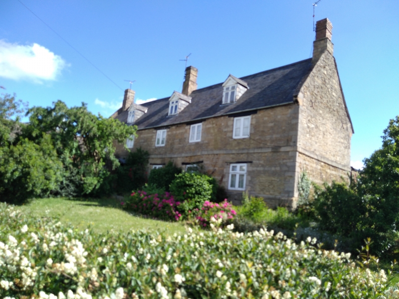
Late C17/early C18 house. Coursed stone rubble with flush quoins and string
course. Steeply pitched Welsh slate roof with stone coping to gable ends. Two
storeys and attic. Long 5 window range. Ground floor wood mullion/transom windows
(left hand modern). First floor 2-light casements.
To left of centre, panelled door with wood trellis porch. Three modern gabled
dormers. Stone end stacks and ridge stack off centre, heightened in brick.
At rear 5 ovolo moulded stone mullion 2-light windows.
Interior: altered but originally a 3 room through passage plan. Two fireplaces
surround by early C18 panelling. RCHM (3) Page 75, plates 10 and 14.
Listing NGR: TL2011497208
External links are from the relevant listing authority and, where applicable, Wikidata. Wikidata IDs may be related buildings as well as this specific building. If you want to add or update a link, you will need to do so by editing the Wikidata entry.


Other nearby listed buildings
