Approximate Location Map
Large Map »
Latitude: 52.19 / 52°11'24"N
Longitude: -0.0623 / 0°3'44"W
OS Eastings: 532551
OS Northings: 256414
OS Grid: TL325564
Mapcode National: GBR K5X.P1L
Mapcode Global: VHGMQ.V6XY
Plus Code: 9C4X5WRQ+23
Entry Name: 62, High Street
Listing Date: 31 May 1985
Grade: II
Source: Historic England
Source ID: 1127225
English Heritage Legacy ID: 51063
ID on this website: 101127225
Location: Bourn, South Cambridgeshire, CB23
County: Cambridgeshire
District: South Cambridgeshire
Civil Parish: Bourn
Built-Up Area: Bourn
Traditional County: Cambridgeshire
Lieutenancy Area (Ceremonial County): Cambridgeshire
Church of England Parish: Bourn St Helena and St Mary
Church of England Diocese: Ely
Tagged with: Building Thatched cottage
TL 3256-3356
15/38
BOURN
HIGH STREET
(South-West Side)
No. 62
GV
II
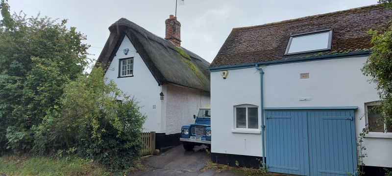
Cottage. Late C17. Timber-framed, roughcast render with plastered plinth.
Thatched roof. Red brick ridge stack. Gable to street, one storey and attic
with single storey C20 flat roofed extension to main east facing elevation.
Entrance in extension. Two ground floor casement windows and a pair of
casement dormer windows. Interior: Stop chamfered ceiling beams and two
sealed inglenook hearths.
V.C.H. Vol. V, p14
RCHM West Cambs p. 26, Mon 23.
Listing NGR: TL3255156414
External links are from the relevant listing authority and, where applicable, Wikidata. Wikidata IDs may be related buildings as well as this specific building. If you want to add or update a link, you will need to do so by editing the Wikidata entry.


Other nearby listed buildings
