Approximate Location Map
Large Map »
Latitude: 52.1899 / 52°11'23"N
Longitude: -0.0621 / 0°3'43"W
OS Eastings: 532568
OS Northings: 256401
OS Grid: TL325564
Mapcode National: GBR K5X.P3T
Mapcode Global: VHGMQ.W711
Plus Code: 9C4X5WQQ+X5
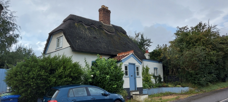
Entry Name: The Old Smithy
Listing Date: 31 May 1985
Grade: II
Source: Historic England
Source ID: 1127226
English Heritage Legacy ID: 51064
ID on this website: 101127226
Location: Bourn, South Cambridgeshire, CB23
County: Cambridgeshire
District: South Cambridgeshire
Civil Parish: Bourn
Built-Up Area: Bourn
Traditional County: Cambridgeshire
Lieutenancy Area (Ceremonial County): Cambridgeshire
Church of England Parish: Bourn St Helena and St Mary
Church of England Diocese: Ely
Tagged with: Smithy
TL 3256-3356
15/89
BOURN
HIGH STREET
(South-West Side)
No. 66 (The Old Smithy)
GV
II
Cottage. Possibly C18. Timber-framed with roughcast render and painted
brick. Thatched half hipped roof. Slate roof to leanto and C20 painted
brick and red pantile porch. Two storeys. Tall ridge stack, rebuilt. Two
first floor and two ground floor horizontal sliding sash windows. Boarded
door with side lights to porched entrance.
Listing NGR: TL3256856401
External links are from the relevant listing authority and, where applicable, Wikidata. Wikidata IDs may be related buildings as well as this specific building. If you want to add or update a link, you will need to do so by editing the Wikidata entry.


Other nearby listed buildings
