Latitude: 52.1552 / 52°9'18"N
Longitude: -0.1886 / 0°11'18"W
OS Eastings: 524018
OS Northings: 252314
OS Grid: TL240523
Mapcode National: GBR J4T.TBR
Mapcode Global: VHGMV.P355
Plus Code: 9C4X5R46+3H
Entry Name: 74, 76 and 78, Church Street
Listing Date: 3 September 1986
Grade: II
Source: Historic England
Source ID: 1128180
English Heritage Legacy ID: 52725
ID on this website: 101128180
Location: Gamlingay, South Cambridgeshire, SG19
County: Cambridgeshire
District: South Cambridgeshire
Civil Parish: Gamlingay
Built-Up Area: Gamlingay
Traditional County: Cambridgeshire
Lieutenancy Area (Ceremonial County): Cambridgeshire
Church of England Parish: Gamlingay St Mary the Virgin
Church of England Diocese: Ely
Tagged with: Building
GAMLINGAY CHURCH STREET TL 2452 (South side) 12/61 Nos 74, 76 and 78
GV II
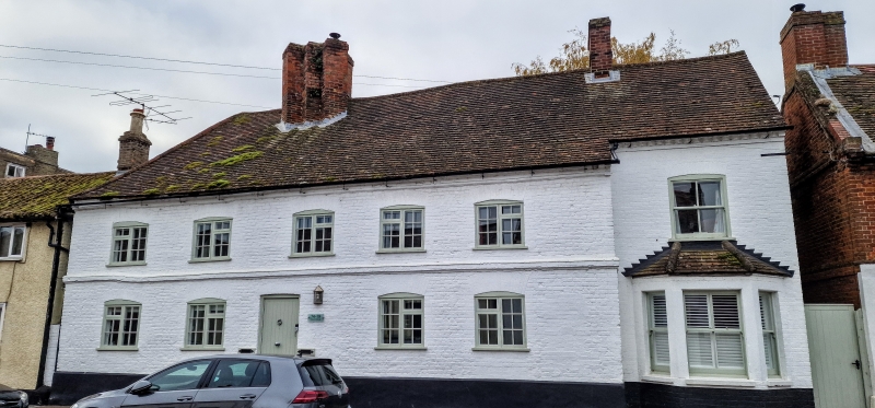
House, now two dwellings. Late C16-early C17, early C18 refronting. Timber framed roughcast rendered and late C17 or early C18 refronting in red brick now painted. Tiled roof, hipped at east end. Early C17 red brick ridge stack of three diagonally set linked shafts and rebuilt upper courses. Moulded brick eaves cornice. Original hall and east crosswing plan, altered in the late C17 or early C18 when the roof was rebuilt in a straight range. Two storeys and moulded brick plat band between the storeys. Five late C17 or early C18 window openings under segmental arches with modern casements. Four similar openings on either side of doorway. There is a gabled stair turret at the rear and a later domestic lean-to. Inside stop chamfered beams and joists and wind braced side purlin roof to crosswing.
RCHM: West Cambs mon (17)
Listing NGR: TL2401852314
External links are from the relevant listing authority and, where applicable, Wikidata. Wikidata IDs may be related buildings as well as this specific building. If you want to add or update a link, you will need to do so by editing the Wikidata entry.


Other nearby listed buildings