Approximate Location Map
Large Map »
Latitude: 53.2354 / 53°14'7"N
Longitude: -2.9729 / 2°58'22"W
OS Eastings: 335159
OS Northings: 371376
OS Grid: SJ351713
Mapcode National: GBR 76.04CX
Mapcode Global: WH880.9YK0
Plus Code: 9C5V62PG+5R
Entry Name: Granary 30 Metres East of Shotwicklodge Farmhouse
Listing Date: 1 June 1967
Last Amended: 10 October 1985
Grade: II
Source: Historic England
Source ID: 1130552
English Heritage Legacy ID: 55700
ID on this website: 101130552
Location: Cheshire West and Chester, Cheshire, CH1
County: Cheshire West and Chester
Civil Parish: Saughall and Shotwick Park
Traditional County: Cheshire
Lieutenancy Area (Ceremonial County): Cheshire
Church of England Parish: Great Saughall All Saints
Church of England Diocese: Chester
Tagged with: Granary
SJ 37 SE
4/54
1/6/1967
SHOTWICK PARK CP
LODGE LANE
(West Side)
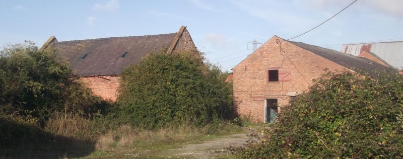
Granary 30m east of Shotwicklodge Farmhouse
[formerly listed as Shotwick Lodge Farm building (to S of large farm buildings]
II
GV
Granary above stable: probably dated 1653, with later alterations. English garden
wall bond orange brick with red sandstone dressings. Welsh slate roof. 2-storey
2-bay south front. Chamfered stone plinth and flush stone quoins. Moulded stone
copings, kneelers, and remains of obelisk finials. Has 2 blocked 4-centred arched
doorways with stone surrounds, the left one with worn inscription probably reading
AD 1653 on lintel. Single small 2-light sliding sash in upper storey. Against
right gable is flight of external steps with stone treads. North face has inserted
C19 doors and windows.
Interior: roof trusses of tiebeam and 2 diagonal struts, with trenched purlins.
Listing NGR: SJ 35159 71376
External links are from the relevant listing authority and, where applicable, Wikidata. Wikidata IDs may be related buildings as well as this specific building. If you want to add or update a link, you will need to do so by editing the Wikidata entry.


Other nearby listed buildings
