Latitude: 51.1721 / 51°10'19"N
Longitude: -1.7774 / 1°46'38"W
OS Eastings: 415658
OS Northings: 141454
OS Grid: SU156414
Mapcode National: GBR 503.FGL
Mapcode Global: VHB5C.4SQT
Plus Code: 9C3W56CF+R2
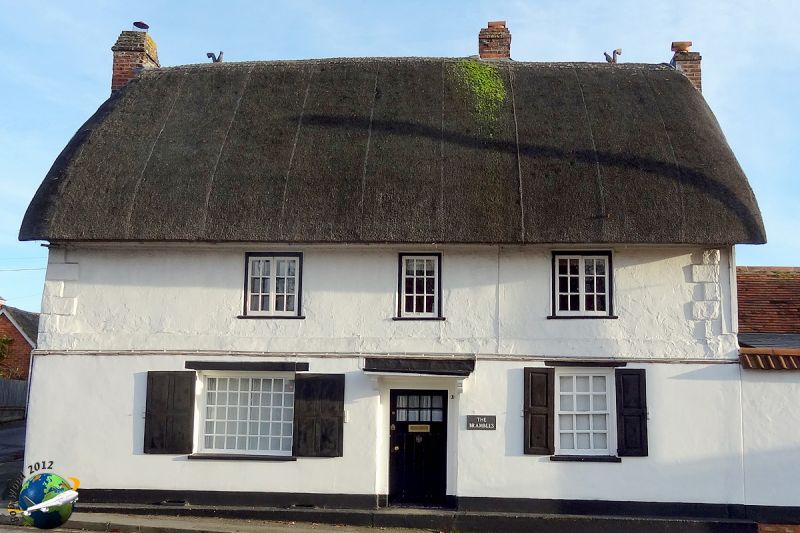
Entry Name: Brambles
Listing Date: 7 January 1972
Grade: II
Source: Historic England
Source ID: 1131069
English Heritage Legacy ID: 321383
ID on this website: 101131069
Location: Amesbury, Wiltshire, SP4
County: Wiltshire
Civil Parish: Amesbury
Built-Up Area: Amesbury
Traditional County: Wiltshire
Lieutenancy Area (Ceremonial County): Wiltshire
Church of England Parish: Amesbury St Mary and St Melor
Church of England Diocese: Salisbury
Tagged with: Building Thatched cottage
AMESBURY SMITHFIELD STREET SU 1541 (south side)
11/71 Brambles 7.1.72
II House. Early C18. Flint and brick, with some cob or chalkstone, rendered timber framed first floor, refaced in C20 brick on ground floor. Thatched roof. Raised end quoins. Two storeys, 3 bays. Off-centre door with glazing and canopy on brackets. Twelve-paned sash window to right with fielded shutters. C19 casement windows to first floor and C20 window to main living room to left of entrance. Right gable tile hung. Stack to left gable and to right of entrance, and an added stack to right gable. To rear of left bay, an offset 2-storey chalk cob wing with thatched roof, extended to rear by brick garage, also thatched. Interior has open fireplace at north end and deeply chamfered ceiling beams.
Listing NGR: SU1565841454
External links are from the relevant listing authority and, where applicable, Wikidata. Wikidata IDs may be related buildings as well as this specific building. If you want to add or update a link, you will need to do so by editing the Wikidata entry.


Other nearby listed buildings