Approximate Location Map
Large Map »
Latitude: 54.1467 / 54°8'48"N
Longitude: -2.0493 / 2°2'57"W
OS Eastings: 396879
OS Northings: 472324
OS Grid: SD968723
Mapcode National: GBR GN4H.48
Mapcode Global: WHB6G.H1DC
Plus Code: 9C6V4XW2+M7
Entry Name: Town Foot Bridge
Listing Date: 4 May 1989
Grade: II
Source: Historic England
Source ID: 1132192
English Heritage Legacy ID: 324679
ID on this website: 101132192
Location: Kettlewell, North Yorkshire, BD23
County: North Yorkshire
District: Craven
Civil Parish: Kettlewell with Starbotton
Traditional County: Yorkshire
Lieutenancy Area (Ceremonial County): North Yorkshire
Tagged with: Bridge
SD 9672-9772
21/93
KETTLEWELL WITH STARBOTTON
B6160
Kettlewell
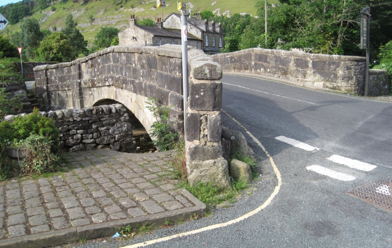
Town Foot Bridge
II
Bridge over Kettlewell Beck. Late C18. Ashlar. A segmental arch flanked
by pilasters which rise to slightly projecting chamfered parapet coping.
Projecting band at road level. Short flanking walls terminate in square
piers.
Listing NGR: SD9687972324
External links are from the relevant listing authority and, where applicable, Wikidata. Wikidata IDs may be related buildings as well as this specific building. If you want to add or update a link, you will need to do so by editing the Wikidata entry.


Other nearby listed buildings
