Latitude: 54.1468 / 54°8'48"N
Longitude: -2.049 / 2°2'56"W
OS Eastings: 396894
OS Northings: 472327
OS Grid: SD968723
Mapcode National: GBR GN4H.58
Mapcode Global: WHB6G.H1HB
Plus Code: 9C6V4XW2+P9
Entry Name: K6 Telephone Kiosk
Listing Date: 19 August 1988
Grade: II
Source: Historic England
Source ID: 1132200
English Heritage Legacy ID: 324703
ID on this website: 101132200
Location: Kettlewell, North Yorkshire, BD23
County: North Yorkshire
District: Craven
Civil Parish: Kettlewell with Starbotton
Traditional County: Yorkshire
Lieutenancy Area (Ceremonial County): North Yorkshire
Tagged with: K6 telephone box
SD 9271-9371
22/93A
19.8.88
KETTLEWELL WITH STARBOTTON
MIDDLE LANE
(south side)
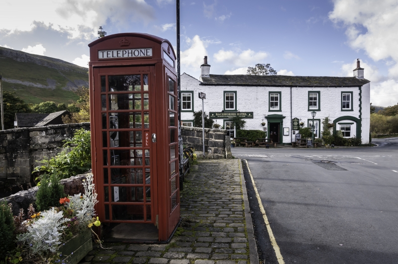
K6 Telephone Kiosk
II
Telephone kiosk; type K6. Designed 1935 by Sir Giles Gilbert Scott. Made by
various contractors. Cast iron. Square kiosk with domed roof. Unperforated
windows to top panels and margin glazing to windows and door.
Listing NGR: SD9689472327
External links are from the relevant listing authority and, where applicable, Wikidata. Wikidata IDs may be related buildings as well as this specific building. If you want to add or update a link, you will need to do so by editing the Wikidata entry.


Other nearby listed buildings