Approximate Location Map
Large Map »
Latitude: 53.3853 / 53°23'7"N
Longitude: -1.3529 / 1°21'10"W
OS Eastings: 443136
OS Northings: 387799
OS Grid: SK431877
Mapcode National: GBR LYZ9.W6
Mapcode Global: WHDDR.650L
Plus Code: 9C5W9JPW+4R
Entry Name: 24, Station Road
Listing Date: 19 February 1986
Grade: II
Source: Historic England
Source ID: 1132729
English Heritage Legacy ID: 335728
ID on this website: 101132729
Location: Treeton, Rotherham, South Yorkshire, S60
County: Rotherham
Civil Parish: Treeton
Built-Up Area: Treeton
Traditional County: Yorkshire
Lieutenancy Area (Ceremonial County): South Yorkshire
Church of England Parish: Brinsworth and Catliffe
Church of England Diocese: Sheffield
Tagged with: Building
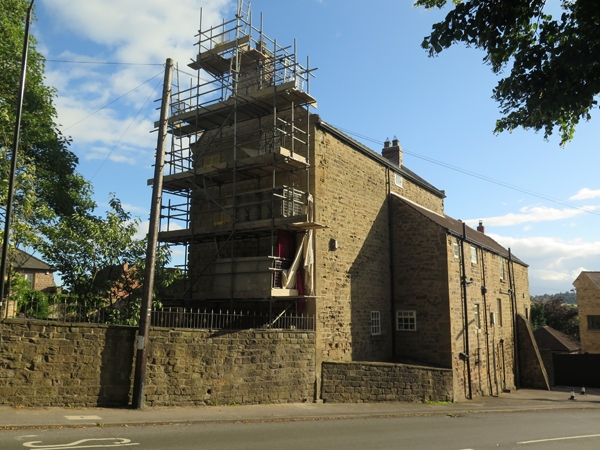
SK48NW TREETON STATION ROAD
(south side)
7/92 No 24
- II
Farmhouse and attached pair of cottages now house and offices of building yard.
Mid-late C18. Coursed, dressed sandstone; Welsh slate roof to main house, pantile
roof to cottages. Main house: 3 storeys, 3 windows to 1st floor. Plinth,
chamfered quoins. C20 gabled stone porch to centre. Flanking windows have
24-pane sashes in square-faced surrounds with projecting sills. lst-floor windows
as ground floor, central window narrower. Short 2nd-floor windows, central
window with 8-pane sash otherwise matching C20 casements. Shaped kneelers,
square-cut gable copings. Renewed brick end stacks. Cottages to left, set
back: 2 storeys, 2 windows to 1st floor. Quoins to left. C20 panelled doors
to right and left of centre, both in flush ashlar surrounds the right surround
cemented. To ground-floor left a tall,3-light, square-faced mullioned window
with old casements; similar window above with renewed casements. To right of
near-central door an enlarged C19 2-light window with stone mullion dividing
sashes with glazing bars; short C19 2-light mullioned window above with C20
casements. Left gable with brick coping and rendered end stack; truncated
ridge stack near centre.
Listing NGR: SK4313687799
External links are from the relevant listing authority and, where applicable, Wikidata. Wikidata IDs may be related buildings as well as this specific building. If you want to add or update a link, you will need to do so by editing the Wikidata entry.


Other nearby listed buildings
