Approximate Location Map
Large Map »
Latitude: 53.3852 / 53°23'6"N
Longitude: -1.3593 / 1°21'33"W
OS Eastings: 442710
OS Northings: 387781
OS Grid: SK427877
Mapcode National: GBR LYY9.H7
Mapcode Global: WHDDR.25ZP
Plus Code: 9C5W9JPR+37
Entry Name: Mill House
Listing Date: 19 February 1986
Grade: II
Source: Historic England
Source ID: 1192867
English Heritage Legacy ID: 335727
ID on this website: 101192867
Location: Treeton, Rotherham, S60
County: Rotherham
Civil Parish: Treeton
Built-Up Area: Treeton
Traditional County: Yorkshire
Lieutenancy Area (Ceremonial County): South Yorkshire
Church of England Parish: Brinsworth and Catliffe
Church of England Diocese: Sheffield
Tagged with: House
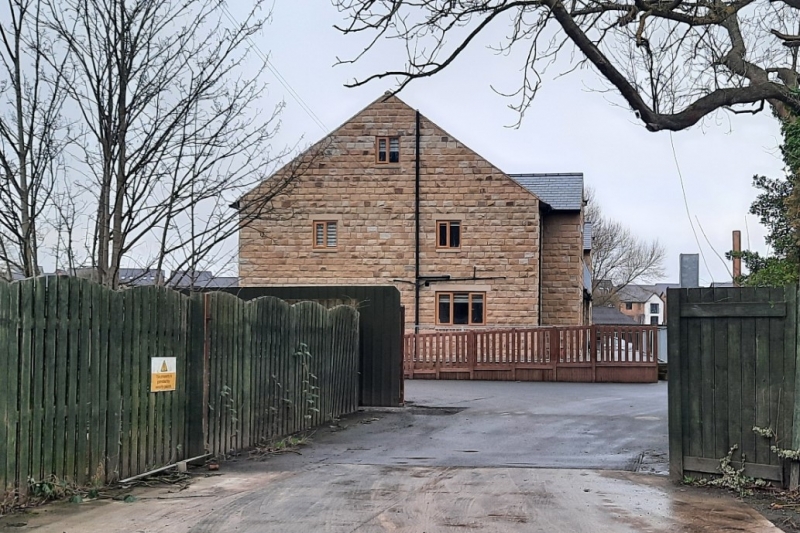
SK48NW TREETON MILL LANE
(west side, off)
7/91 Nos 1 and 2
(Mill House)
- II
Pair of houses. Mid-late C18. Deeply-coursed, dressed sandstone; stone
slates to lower courses of Welsh slate roofs. House to right: 3 storeys,
3 windows to 1st floor, outshut to rear right, 2-storey wing to rear left.
House to left, attached and in line: 2 storeys, 4 windows to 1st floor,
additions to rear (not of special interest). Both houses entered from rear.
Original window openings have projecting square-faced surrounds. House to
right: projecting ashlar quoins. Blocked doorway to left of centre retains
plinth blocks and architrave. Flanking windows now extended to ground and
with glazed doors, floating cornices. C20 casements to 1st floor. 16-pane
sashes to 2nd floor flanking a blind window. Eaves cornice. Shaped kneelers,
square-cut gable copings. Renewed brick end stacks. House to left: projecting
quoins to left. C20 3-light casement inserted to left. Blind window to right
and 2 original surrounds with projecting sills and C20 casements beyond.
1st floor: bay-2 window blind, otherwise C20 casement in original surrounds.
Eaves cornice. Shaped kneeler and gable copings to left. Renewed brick end
stack and similar ridge stack above bay 2.
Listing NGR: SK4271087781
This text is from the original listing, and may not necessarily reflect the current setting of the building.
External links are from the relevant listing authority and, where applicable, Wikidata. Wikidata IDs may be related buildings as well as this specific building. If you want to add or update a link, you will need to do so by editing the Wikidata entry.


Other nearby listed buildings
