Approximate Location Map
Large Map »
Latitude: 53.4893 / 53°29'21"N
Longitude: -1.3199 / 1°19'11"W
OS Eastings: 445220
OS Northings: 399388
OS Grid: SK452993
Mapcode National: GBR MX72.1X
Mapcode Global: WHDD5.PKND
Plus Code: 9C5WFMQJ+P2
Entry Name: Remains of Chapel of St Mary Magdalene Situated Immediately to North of Church of St Margaret
Listing Date: 11 December 1953
Last Amended: 21 August 1985
Grade: II
Source: Historic England
Source ID: 1132779
English Heritage Legacy ID: 335536
ID on this website: 101132779
Location: St Margaret's Church, Swinton, Rotherham, South Yorkshire, S64
County: Rotherham
Electoral Ward/Division: Swinton
Parish: Non Civil Parish
Built-Up Area: Wath upon Dearne
Traditional County: Yorkshire
Lieutenancy Area (Ceremonial County): South Yorkshire
Church of England Parish: Swinton St Margaret
Church of England Diocese: Sheffield
Tagged with: Chapel
SK49NE SWINTON CHURCH STREET
(north side, off)
6/27 Remains of Chapel of
St. Mary Magdalene
11.12.53 situated immediately
to north of Church of
St. Margaret (formerly
listed as Base of two
Norman arches in corner
of Vicarage Field)
GV II
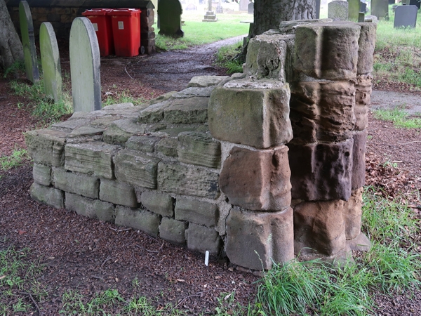
Remains of chapel. c1200, demolished 1815 and now incorporated in
church-yard wall. Ashlar sandstone with some limestone details; all
badly eroded. Jambs of chancel arch and of south doorway survive to
impost level set within L-shaped section of wall. Chancel arch: quoined
opening; each jamb with 2 orders of projecting half-round mouldings to
each side. Badly-weathered capitals. South doorway: fragmentary survival
of 2 orders of colonnettes flank moulded rib. Traces of zig-zag carving
to weathered capitals.
Listing NGR: SK4522099388
External links are from the relevant listing authority and, where applicable, Wikidata. Wikidata IDs may be related buildings as well as this specific building. If you want to add or update a link, you will need to do so by editing the Wikidata entry.


Other nearby listed buildings
