Approximate Location Map
Large Map »
Latitude: 53.4227 / 53°25'21"N
Longitude: -1.6098 / 1°36'35"W
OS Eastings: 426024
OS Northings: 391841
OS Grid: SK260918
Mapcode National: GBR KX6V.8R
Mapcode Global: WHCC9.77ND
Plus Code: 9C5WC9FR+33
Entry Name: Fair House Farmhouse
Listing Date: 8 August 1985
Grade: II*
Source: Historic England
Source ID: 1132863
English Heritage Legacy ID: 335330
ID on this website: 101132863
Location: Low Bradfield, Sheffield, South Yorkshire, S6
County: Sheffield
Civil Parish: Bradfield
Traditional County: Yorkshire
Lieutenancy Area (Ceremonial County): South Yorkshire
Church of England Parish: Bradfield St Nicholas
Church of England Diocese: Sheffield
Tagged with: Farmhouse
SK29SE BRADFIELD ANNET LANE
(south side)
Low Bradfield
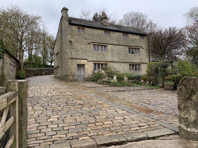
9/6 Fair House
Farmhouse
20/12/74
GV II*
Farmhouse. Late C17, panelling dated 1687, C20 addition to right.
Coursed, squared gritstone, stone slate roof. Baffle-entry plan
embracing service rooms to rear of an otherwise 2-room plan. 3
storeys, 2 windows to first floor. Chamfered plinth, large quoins.
Panelled door to left, quoin reveals and deep lintel, all chamfered.
Double-chamfered mullion windows with iron casements. Two 4-light
windows to ground floor, continuous dripmould raised up over doorway.
Two 4-light windows to first floor under continuous hoodmould. Four
2-light windows to second floor. Moulded kneelers, chamfered gable
copings. Short, corniced ashlar stack to centre, later stack to left
gable. Lower eaves at rear. Double-chamfered mullion windows to left
return. Interior: extensive original panelling to walls and doors.
Left ground floor room has bressumer beam with arched doorhead and oak
screen to left, stone heck wall to right. To right of heck wall is the
stone sink of the former service room. Stone stairs to first floor and
oak staircase with flat-balustered rail to attic. Position of former
smokehood further evidenced by soffit-morticed collar in attic chamber
above bressumer.
Listing NGR: SK2602491841
External links are from the relevant listing authority and, where applicable, Wikidata. Wikidata IDs may be related buildings as well as this specific building. If you want to add or update a link, you will need to do so by editing the Wikidata entry.


Other nearby listed buildings
