Approximate Location Map
Large Map »
Latitude: 53.6824 / 53°40'56"N
Longitude: -1.7455 / 1°44'43"W
OS Eastings: 416904
OS Northings: 420694
OS Grid: SE169206
Mapcode National: GBR JT7V.WP
Mapcode Global: WHC9W.5P1V
Plus Code: 9C5WM7J3+XQ
Entry Name: 142, Bradley Road
Listing Date: 29 September 1978
Grade: II
Source: Historic England
Source ID: 1134365
English Heritage Legacy ID: 339582
ID on this website: 101134365
Location: Bradley, Kirklees, West Yorkshire, HD2
County: Kirklees
Electoral Ward/Division: Ashbrow
Parish: Non Civil Parish
Built-Up Area: Huddersfield
Traditional County: Yorkshire
Lieutenancy Area (Ceremonial County): West Yorkshire
Church of England Parish: Bradley St Thomas
Church of England Diocese: Leeds
Tagged with: Building
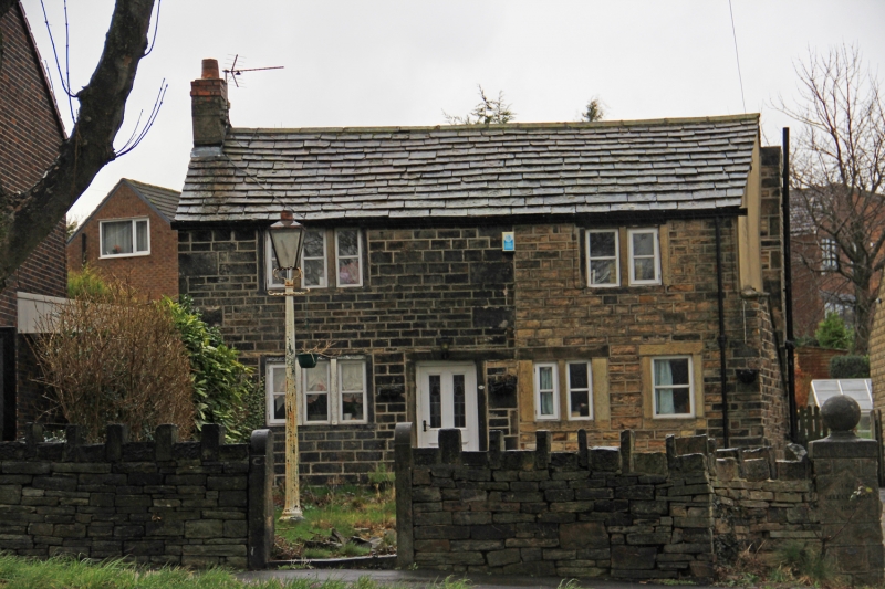
BRADLEY ROAD
1.
5113
(North Side)
No 142
SE 1620 12/233
II
2.
C18. Hammer-dressed stone. Pitched stone slate roof. 2 storeys. 2 ranges
of stone mullioned sashes. 2 doors, one leading to outhouse at right hand
side.
Listing NGR: SE1690420694
External links are from the relevant listing authority and, where applicable, Wikidata. Wikidata IDs may be related buildings as well as this specific building. If you want to add or update a link, you will need to do so by editing the Wikidata entry.


Other nearby listed buildings
