Latitude: 52.0108 / 52°0'39"N
Longitude: -0.4556 / 0°27'20"W
OS Eastings: 506096
OS Northings: 235838
OS Grid: TL060358
Mapcode National: GBR G3J.ZKG
Mapcode Global: VHFQV.2Q0C
Plus Code: 9C4X2G6V+8Q
Entry Name: 37 and 39, High Street
Listing Date: 29 July 1975
Grade: II
Source: Historic England
Source ID: 1137609
English Heritage Legacy ID: 37998
ID on this website: 101137609
Location: Flitton, Central Bedfordshire, MK45
County: Central Bedfordshire
Civil Parish: Flitton and Greenfield
Built-Up Area: Greenfield
Traditional County: Bedfordshire
Lieutenancy Area (Ceremonial County): Bedfordshire
Church of England Parish: Flitton
Church of England Diocese: St.Albans
Tagged with: Building Thatched cottage
FLITTON
TL 0635 HIGH STREET
(North Side)
15/11 Nos. 37 and 39
29.7.75
GV II
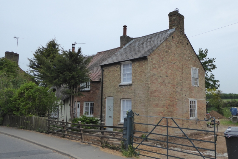
2 cottages, formerly a row of 3. C18 and C19. Divides into 3 sections. LH
section: colourwashed render over timber-frame, with thatched roof. One-room
plan, one storey and attic. 2-light ground floor casement, eyebrow dormer
with 2-light casement, both with glazing bars. External brick stack to LH
gable. Central section: red brick casing over timber frame. Clay tile roof.
One-room plan, one storey and attic. 2-light casements with glazing bars, one
each to ground floor and to eyebrow dormer. Part-glazed door to LH. Red
brick stack to RH. RH section: C19 yellow brick with slate roof. One-room
plan, 2 storeys. One sash window with glazing bars to each floor. 6 panel
door to LH. Integral brick stack to RH gable.
Listing NGR: TL0609635838
External links are from the relevant listing authority and, where applicable, Wikidata. Wikidata IDs may be related buildings as well as this specific building. If you want to add or update a link, you will need to do so by editing the Wikidata entry.


Other nearby listed buildings