Latitude: 53.2757 / 53°16'32"N
Longitude: -2.3593 / 2°21'33"W
OS Eastings: 376137
OS Northings: 375471
OS Grid: SJ761754
Mapcode National: GBR CZZK.0G
Mapcode Global: WH997.QXQN
Plus Code: 9C5V7JGR+77
Entry Name: Milepost
Listing Date: 28 November 1984
Grade: II
Source: Historic England
Source ID: 1139290
English Heritage Legacy ID: 59147
ID on this website: 101139290
Location: Cheshire East, Cheshire, WA16
County: Cheshire East
Civil Parish: Toft
Traditional County: Cheshire
Lieutenancy Area (Ceremonial County): Cheshire
Church of England Parish: Toft St John the Evangelist
Church of England Diocese: Chester
Tagged with: Milestone
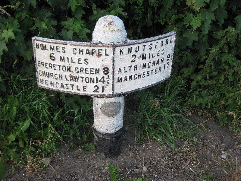
TOFT C.P. HOLMES CHAPEL ROAD
SJ 77 NE
2/108 Milepost
-
- II
Milepost. c1830. Cast iron. Round post with domed finial and curved
plate reading
HOLMES CHAPEL KNUTSFORD
6 MILES 2 MILES
BRERETON GREEN 8 ALTRINCHAM 9
CHURCH LAWTON 14½ MANCHESTER 17
NEWCASTLE 21
Listing NGR: SJ7613875470
External links are from the relevant listing authority and, where applicable, Wikidata. Wikidata IDs may be related buildings as well as this specific building. If you want to add or update a link, you will need to do so by editing the Wikidata entry.


Other nearby listed buildings