Approximate Location Map
Large Map »
Latitude: 54.5242 / 54°31'26"N
Longitude: -0.995 / 0°59'42"W
OS Eastings: 465142
OS Northings: 514783
OS Grid: NZ651147
Mapcode National: GBR PJH3.CZ
Mapcode Global: WHF8F.PKC2
Plus Code: 9C6XG2F3+MX
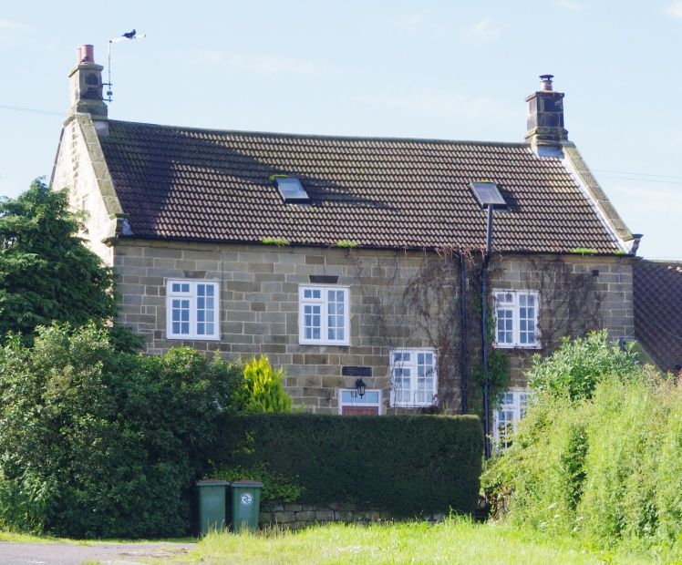
Entry Name: Aysdalegate Farmhouse
Listing Date: 8 September 1986
Grade: II
Source: Historic England
Source ID: 1139711
English Heritage Legacy ID: 60105
ID on this website: 101139711
Location: Charltons, Redcar and Cleveland, North Yorkshire, TS12
County: Redcar and Cleveland
Civil Parish: Lockwood
Traditional County: Yorkshire
Lieutenancy Area (Ceremonial County): North Yorkshire
Church of England Parish: Boosbeck and Lingdale
Church of England Diocese: York
Tagged with: Farmhouse
NZ 61 SE LOCKWOOD BIRK BROW ROAD (west side),
Stanghow
6/60 Aysdalegate Farmhouse
II
Farmhouse and farm cottage, now one house, dated 1729 on lintel of cottage
doorway. It is said to incorporate stones from Gisborough Priory. Dressed
sandstone. Late C20 concrete tiled roof; clay pantiles on farm cottage.
Stone gable copings, moulded kneelers and end stacks. 2 storeys, 4 bays to
garden front (south). Entered from farm cottage. Continuous chamfered
plinth. Windows altered on ground floor; renewed sashes with glazing bars,
stone sills and flat surrounds on first floor. Moulded eaves cornice.
Lower 2-storey farm cottage, adjoining left, with .hearth-passaqe.One window.
Half-glazed door to left, in moulded surround with lintel inscribed: "R
RE
1729".
Renewed fixed-light window in chamfered surround on ground floor; horizontal
sash with glazing bars on first floor. Left end stack. Chamfered plinth
and moulded eaves cornice. Garret light in right return. All windows in
rear elevation altered, except for chamfered fire window at east end.
Interiors of farmhouse and cottage retain beamed ceilings and moulded fire
beams on ground floor.
Listing NGR: NZ6514214783
External links are from the relevant listing authority and, where applicable, Wikidata. Wikidata IDs may be related buildings as well as this specific building. If you want to add or update a link, you will need to do so by editing the Wikidata entry.


Other nearby listed buildings
