Latitude: 52.2446 / 52°14'40"N
Longitude: 0.7131 / 0°42'47"E
OS Eastings: 585322
OS Northings: 264181
OS Grid: TL853641
Mapcode National: GBR QF0.73L
Mapcode Global: VHKD4.9VV5
Plus Code: 9F426PV7+R6
Entry Name: 55, Abbeygate Street
Listing Date: 16 October 1995
Grade: II
Source: Historic England
Source ID: 1141142
English Heritage Legacy ID: 466613
ID on this website: 101141142
Location: Bury St Edmunds, West Suffolk, IP33
County: Suffolk
District: West Suffolk
Civil Parish: Bury St Edmunds
Built-Up Area: Bury St Edmunds
Traditional County: Suffolk
Lieutenancy Area (Ceremonial County): Suffolk
Church of England Parish: Bury St Edmunds St Mary
Church of England Diocese: St.Edmundsbury and Ipswich
Tagged with: Building
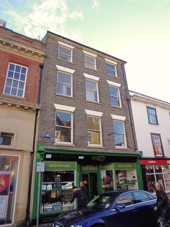
BURY ST EDMUNDS
TL8564SW ABBEYGATE STREET
639-1/14/151 (South side)
16/10/95 No.55
GV II
Shop. Mid-C19 with core of c1600. White brick front,
timber-framed core; shallow-pitched slate roof with wide eaves
and mutule cornice.
EXTERIOR: 4 storeys and cellar; 2 bays. 3 window range of late
C19/early C20 sashes, all without glazing bars, deep reveals,
stucco heads and stone sills. C20 shop front with plain fascia
and recessed double doors.
INTERIOR: the cellar is faced with large irregular stone
blocks along the rear wall and has several shallow arched
recesses; along the front wall are recesses with old brick
arches. The heavy supporting main beam is chamfered and rests
on stone blocks. On the ground storey a timber ceiling is
exposed: the main cross-beams have been hacked back, plain,
flat, closely-spaced joists. No timbers survive above ground
storey level. The roof was raised in the C19 when the brick
front was added. This building is surrounded on its west side
and rear by No.56 (qv), and although it has been a separate
property for nearly 2 centuries it appears structurally to
have formed part of No.56 initially.
Listing NGR: TL8532264181
External links are from the relevant listing authority and, where applicable, Wikidata. Wikidata IDs may be related buildings as well as this specific building. If you want to add or update a link, you will need to do so by editing the Wikidata entry.


Other nearby listed buildings