Approximate Location Map
Large Map »
Latitude: 49.9288 / 49°55'43"N
Longitude: -6.3036 / 6°18'12"W
OS Eastings: 91256
OS Northings: 12064
OS Grid: SV912120
Mapcode National: GBR BXTW.3GN
Mapcode Global: VGYC4.P1DW
Plus Code: 8CXMWMHW+GH
Entry Name: Coastguard's Look out Tower
Listing Date: 12 February 1975
Grade: II
Source: Historic England
Source ID: 1141182
English Heritage Legacy ID: 62511
Also known as: Coastguard's Lookout Tower
Telegraph Tower
ID on this website: 101141182
Location: Porthloo, Isles of Scilly, Cornwall, TR21
County: Isles of Scilly
Civil Parish: St. Mary's
Lieutenancy Area (Ceremonial County): Cornwall
Church of England Parish: Isles of Scilly
Church of England Diocese: Truro
Tagged with: Building
ST. MARY'S
SV91SW TELEGRAPH ROAD
SV9125612064 Coastguard's Look
Out Tower
12/02/75 II
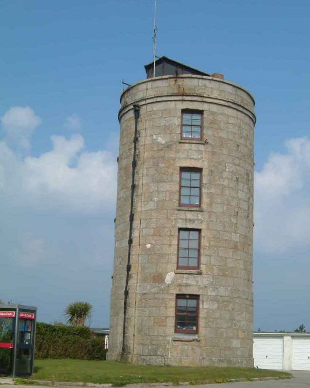
A semaphore signal station of 1814, with early-C20 telegraph house added to the roof. The tower was built for the Admiralty by Messrs. Hambledon and the telegraph house by Arthur Carkeep.
The tower is circular in plan, stands four storeys high and is built of coursed, shaped, granite blocks. There are four four/four-pane sash windows with sills to each face and gabled wooden porch. One of the ground-floor window openings is sealed in granite, and probably marks a former door opening. To the right of the opening, a downpipe with hopper is attached below parapet level. The granite surrounds of the window openings show signs of disturbance, and some heads are scored vertically to give the appearance of decorative, flat arches. The upper floors are slightly set back from the projecting ground floor. There are string courses beneath the parapet surrounding a flat roof on which the early C20 timber telegraph house stands.
HISTORY
St Mary's has a long history of occupation, with prehistoric sites across the island, and later Iron Age and Romano-British works. The tower, located on the highest part of St Mary's, is thought to be the former site of a Bronze Age standing stone, referred to in a survey by J. Troutbeck in 1794. Troutbeck's account also identified the ruins of a watch house on the site, and a lookout is marked on Christian Lilly's map of c.1715. Following the breakdown of the Peace of Amiens (1802), hostilities between Britain and France resumed. Prior to this, signal posts had been constructed along the English coast to alert naval squadrons and ports to the route of an invading French force. In 1804 it was agreed that a further signal post should be built on the Isles of Scilly in response to attacks on merchant ships by French privateers. A signal house was built on the island of St Martin's, and unlike the mainland examples which were constructed of timber and canvas, was built of local granite to resist the ill-effects of the exposed location.
In May 1812 Lieutenant General Vigoureux, military governor of the Isles of Scilly, asked for a new signal tower station to be built on Newford Down, St Mary's. The Admiralty agreed that the selected location would command a wide sweep of the horizon around the islands and allow signals to be passed easily to the batteries below Star Castle, on the fortified Garrison peninsula. The position had already served as a lookout point. After a series of delays, the tower was erected by Messrs. Hambledon by 1814. The officer in charge of the station was a Lieutenant Trinder, who appears to have been unhappy with his posting and consequently complained constantly about the condition of the building, the quality of his staff and the usefulness of the station. The result was that further works were carried out to the tower. However, in December 1816, after only two years in operation, it was closed down. The building reverted to the custody of the landowner - the Duke of Leeds. In 1831 the site was taken over by the Coastguard as a subsidiary to the main station situated on the Garrison. In 1903 a wireless mast and receiving office were built nearby, and in 1908 a telegraph house was erected on the tower's roof by the contractor, Arthur Carkeep. The tower is shown on the Ordnance Survey Map of 1908, along with a group of other buildings marked Coastguard Station. The tower is shown as circular on plan, set within a triangular boundary, and an indistinct marking on the south-west corner. The Newford Down semaphore station became known as Telegraph Tower, and the wider site was developed into a modern radio transmitting and communications site by the late-C20. The tower appears to stand empty in 2010.
SOURCES:
Goodwin, J. Granite towers on St, Mary's, Isles of Scilly, Cornish Archaeology, 32, 1993, 134-136
Cornwall County Council/ English Heritage, Rapid Coastal Zone Assessment for The Isles of Scilly, 2004, p109: http://www.english-heritage.org.uk/publications/isles-of-scilly-rczas/islesofscilly20080116095450.pdf [Accessed on 25/11/10]
Cornwall and Scilly HER records: http://www.heritagegateway.org.uk/Gateway/Results_Single.aspx?uid=MCO53350&resourceID=1020):
7494: TELEGRAPH ROAD - Neolithic standing stone, Bronze Age standing stone
7495.01: TELEGRAPH HILL - Post Medieval signal station
7495.02: TELEGRAPH HILL - Post Medieval artillery tower
7495.03: TELEGRAPH HILL - Post Medieval lookout
[Accessed on 26/11/10]
REASONS FOR DESIGNATION
The Coastguard's Lookout Tower, Telegraph Road, St Mary's, Isles of Scilly, a signal station of 1814, is designated at Grade II for the following principal reasons:
* Architectural: An interesting example of a pre-1840 semaphore signal station.
* Rarity: This is an early example of its type
* Intactness: The station remains largely unaltered externally.
External links are from the relevant listing authority and, where applicable, Wikidata. Wikidata IDs may be related buildings as well as this specific building. If you want to add or update a link, you will need to do so by editing the Wikidata entry.


Other nearby listed buildings
