Approximate Location Map
Large Map »
Latitude: 50.2058 / 50°12'20"N
Longitude: -5.2603 / 5°15'37"W
OS Eastings: 167455
OS Northings: 39059
OS Grid: SW674390
Mapcode National: GBR Z2.419N
Mapcode Global: VH12Q.R3Y3
Plus Code: 9C2P6P4Q+8V
Entry Name: Engine House to Daubuz Shaft on South Wheal Frances Sett at SW 674 390
Listing Date: 12 September 1989
Grade: II
Source: Historic England
Source ID: 1142597
English Heritage Legacy ID: 66728
ID on this website: 101142597
Location: Treskillard, Cornwall, TR16
County: Cornwall
Civil Parish: Carn Brea
Traditional County: Cornwall
Lieutenancy Area (Ceremonial County): Cornwall
Church of England Parish: Redruth
Church of England Diocese: Truro
Tagged with: Chimney Engine house
CARN BREA TRESKILLARD
SW 63 NE
8/172 Engine house to Daubuz shaft
on South Wheal Frances sett
at SW 674 390
GV II
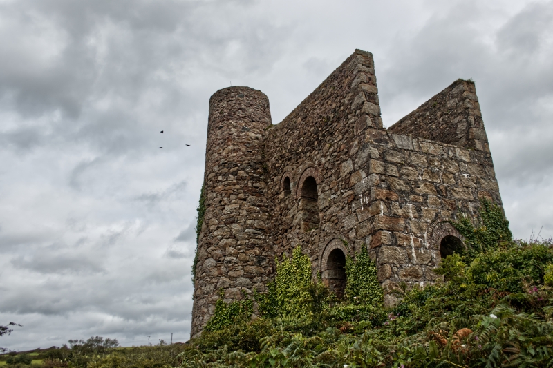
Pumping and winding engine house to former tin mine, now derelict. 1879-81, for
South Frances Mine. Uncoursed granite rubble with quoins, bob wall of large
dressed granite blocks, window arches of brick; now roofless. Rectangular plan on
east-west axis, with bob wall to west, loadings for pumping and winding gear in
front of this, remains of boiler house attached to south side, and chimney
attached at north-east corner. Three stages, with mostly round-headed openings,
including driver's window in bob wall, damaged cylinder door in rear wall (which
is thicker than bob wall), a pair of small blocked windows above this and a
larger window in the gable, a square-headed doorway to the former boiler house
on the south side, round-headed windows on 2 levels to the right of this and a
small blocked window to the right of the upper of these. Tapered cylindrical
chimney stack of unusually large diameter (4 metres at the base), now
terminating at gable level. Very prominent double loadings extending approx.10
metres in front of bob wall, one on the main axis for the flywheel and flat-rod
connections to the pump, and a longer one parallel to it on the north side of the
flywheel recess, for the winding drum. Remains of boiler house very fragmentary.
History: the shaft, approx 60 metres to the west, was sunk at the request of the
mineral lords in a period of expansion when mining here reached the Great Flat
Lode, and named after J.C.Daubuz, a principal shareholder; the building contained
a 30-inch engine, and its application to both pumping and winding was unusual.
Reference:Marilyn Palmer & Peter Neaverson The Basset Mines, their History and
Industrial Archaeology (1987).
Listing NGR: SW6745539059
External links are from the relevant listing authority and, where applicable, Wikidata. Wikidata IDs may be related buildings as well as this specific building. If you want to add or update a link, you will need to do so by editing the Wikidata entry.


Other nearby listed buildings
