Approximate Location Map
Large Map »
Latitude: 50.2129 / 50°12'46"N
Longitude: -5.3012 / 5°18'4"W
OS Eastings: 164569
OS Northings: 39985
OS Grid: SW645399
Mapcode National: GBR FX93.SLD
Mapcode Global: VH12J.2X94
Plus Code: 9C2P6M7X+5G
Entry Name: Parish Vestry
Listing Date: 12 September 1989
Grade: II
Source: Historic England
Source ID: 1142654
English Heritage Legacy ID: 66576
ID on this website: 101142654
Location: Camborne, Cornwall, TR14
County: Cornwall
Civil Parish: Camborne
Built-Up Area: Camborne
Traditional County: Cornwall
Lieutenancy Area (Ceremonial County): Cornwall
Church of England Parish: Camborne and Tuckinghill
Church of England Diocese: Truro
Tagged with: Architectural structure
CAMBORNE CHURCH LANE
SW 63 NW
(south side)
10/31
Parish Vestry
GV II
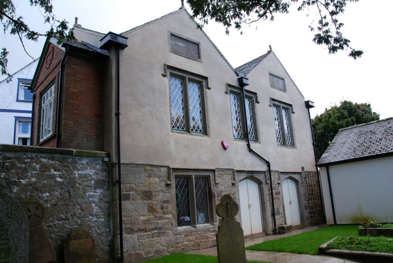
Parish Vestry building. Dated 1820 on lintel of former door in rear wall,
altered. Facade of snecked killas rubble with granite quoins but covered
with render above ground floor, sides and rear of uncoursed rubble; slate
roof. Rectangular plan, gable to road but facing churchyard, with added
porch at north end. Two storeys; the facade to the churchyard is of 3 bays
under 2 gables, symmetrical, in Tudor style, with 3 wide Tudor-arched
openings at ground floor (a window and 2 doorways) and 3 windows at 1st
floor, all with chamfered surrounds and hoodmoulds and all the windows of
2 lights with chamfered mullions and diamond leaded glazing (but that at
ground floor boarded at time of survey, 1988); a rectangular granite panel
in each gable, and gable copings with apex finials. The left (north) gable
wall has a flight of external steps to a doorway at 1st floor, protected by
a brick porch of c.1900; and to the left of this a large rendered panel
with pilastered architrave and stilted segmental head enclosing raised
lettering "PARISH VESTRY". The rear has inter alia a former doorway with
lintel inscribed "1820". Interior not inspected. History: ground floor was
used as lock-up 1820-1858. Probably erected in consequence of Sturges
Bourne's Act of 1819, which empowered parishes to appoint select vestries
"for more effectual execution of the laws for the relief of the poor" (the
style being a reference to the Tudor origins of the Poor law); as such, a
rare survival of a building for this purpose, and the earliest Local
Government building in the area covered by this list.
Listing NGR: SW6457039984
External links are from the relevant listing authority and, where applicable, Wikidata. Wikidata IDs may be related buildings as well as this specific building. If you want to add or update a link, you will need to do so by editing the Wikidata entry.


Other nearby listed buildings
