Latitude: 50.1188 / 50°7'7"N
Longitude: -5.5402 / 5°32'24"W
OS Eastings: 147029
OS Northings: 30304
OS Grid: SW470303
Mapcode National: GBR DXPC.K30
Mapcode Global: VH05H.X8HS
Plus Code: 9C2P4F95+GW
Entry Name: Public Buildings
Listing Date: 29 July 1950
Grade: II
Source: Historic England
Source ID: 1143145
English Heritage Legacy ID: 69434
Also known as: St John's Hall, Penzance
Public Buildings, Penzance
Penzance Magistrates Court
The Guildhall
ID on this website: 101143145
Location: Penzance, Cornwall, TR18
County: Cornwall
Civil Parish: Penzance
Built-Up Area: Penzance
Traditional County: Cornwall
Lieutenancy Area (Ceremonial County): Cornwall
Church of England Parish: Penzance St Mary the Virgin with St Paul
Church of England Diocese: Truro
Tagged with: Building
1.
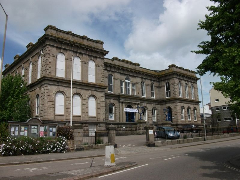
1498 PENZANCE
ALVERTON STREET
(North Side)
Public Buildings
sw 4730 5/10A 29.7.50.
II
2.
Late C19, monumental granite ashlar building. 2 storeys and semi-basement. 11
windows: all with semi-circular arches with recessed architraves. 2 string
courses, eaves cornice with brackets, and eaves parapet. Keystones and quoins
in relief. 5 window centre block set back. Flat Doric entrance porch with
twin columns, and a Palladian window on 1st floor above.
Listing NGR: SW4702930304
External links are from the relevant listing authority and, where applicable, Wikidata. Wikidata IDs may be related buildings as well as this specific building. If you want to add or update a link, you will need to do so by editing the Wikidata entry.


Other nearby listed buildings