Approximate Location Map
Large Map »
Latitude: 50.1171 / 50°7'1"N
Longitude: -5.5351 / 5°32'6"W
OS Eastings: 147383
OS Northings: 30093
OS Grid: SW473300
Mapcode National: GBR DXQC.MFP
Mapcode Global: VH12Z.0BP3
Plus Code: 9C2P4F87+RX
Entry Name: Methodist Church including railings
Listing Date: 7 February 1974
Grade: II*
Source: Historic England
Source ID: 1143151
English Heritage Legacy ID: 69447
ID on this website: 101143151
Location: Penzance, Cornwall, TR18
County: Cornwall
Civil Parish: Penzance
Built-Up Area: Penzance
Traditional County: Cornwall
Lieutenancy Area (Ceremonial County): Cornwall
Church of England Parish: Penzance St Mary the Virgin with St Paul
Church of England Diocese: Truro
Tagged with: Church building
This list entry was subject to a Minor Amendment on 26 April 2022 to remove superfluous amendment details and to reformat the text to current standards
SW 4730
5/474
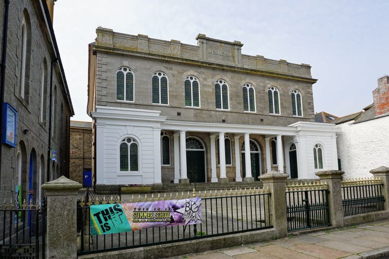
PENZANCE
CHAPEL STREET (South West Side)
Methodist Church including railings
GV
II*
Mid C19. Granite ashlar. Two storey front, seven windows with semi-circular heads. Parapet raised at centre, cornice. Quoins. Ground floor, wide semi-circular entrances with fanlights and panelled double doors, Tuscan colonnade with entablature, with projecting rusticated porches at ends with flat pilaster quoins and semi-circular headed windows.
Including iron railings to forecourt with lamp standards.
Nos 15 to 18 (consec) and the Methodist Church form a group.
Listing NGR: SW4686926181
External links are from the relevant listing authority and, where applicable, Wikidata. Wikidata IDs may be related buildings as well as this specific building. If you want to add or update a link, you will need to do so by editing the Wikidata entry.


Other nearby listed buildings
