Approximate Location Map
Large Map »
Latitude: 54.8354 / 54°50'7"N
Longitude: -3.0787 / 3°4'43"W
OS Eastings: 330810
OS Northings: 549490
OS Grid: NY308494
Mapcode National: GBR 6DYJ.8F
Mapcode Global: WH6Z2.PQ4G
Plus Code: 9C6RRWPC+5G
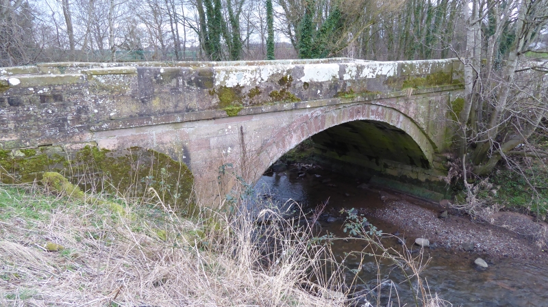
Entry Name: Crofton Bridge
Listing Date: 8 November 1984
Grade: II
Source: Historic England
Source ID: 1144636
English Heritage Legacy ID: 71931
ID on this website: 101144636
Location: West Woodside, Cumberland, Cumbria, CA5
County: Cumbria
District: Allerdale
Civil Parish: Thursby
Traditional County: Cumberland
Lieutenancy Area (Ceremonial County): Cumbria
Church of England Parish: Thursby St Andrew
Church of England Diocese: Carlisle
Tagged with: Bridge
NY 34 NW THURSBY Crofton
12/53 Crofton Bridge
II
Road bridge. Early C19, probably built at the expense of the Brisco family of
nearby Crofton Hall. Rusticated red sandstone ashlar. Single segmental arch
with V-jointed voussoirs, channelled joints on upper structure with string
course and pilasters; low parapet. By-passed by modern road in early 1960s.
This bridge lies partly in Westward C.P.
Listing NGR: NY3081049490
External links are from the relevant listing authority and, where applicable, Wikidata. Wikidata IDs may be related buildings as well as this specific building. If you want to add or update a link, you will need to do so by editing the Wikidata entry.


Other nearby listed buildings
