Approximate Location Map
Large Map »
Latitude: 52.2458 / 52°14'45"N
Longitude: 0.7124 / 0°42'44"E
OS Eastings: 585271
OS Northings: 264317
OS Grid: TL852643
Mapcode National: GBR QF0.0YH
Mapcode Global: VHKD4.9TH6
Plus Code: 9F426PW6+8X
Entry Name: 1, the Traverse
Listing Date: 12 July 1972
Grade: II
Source: Historic England
Source ID: 1145963
English Heritage Legacy ID: 467541
ID on this website: 101145963
Location: Bury St Edmunds, West Suffolk, IP33
County: Suffolk
District: West Suffolk
Civil Parish: Bury St Edmunds
Built-Up Area: Bury St Edmunds
Traditional County: Suffolk
Lieutenancy Area (Ceremonial County): Suffolk
Church of England Parish: Bury St Edmunds St John the Evangelist
Church of England Diocese: St.Edmundsbury and Ipswich
Tagged with: Building
BURY ST EDMUNDS
TL8564SW THE TRAVERSE
639-1/14/631 No.1
12/07/72
GV II
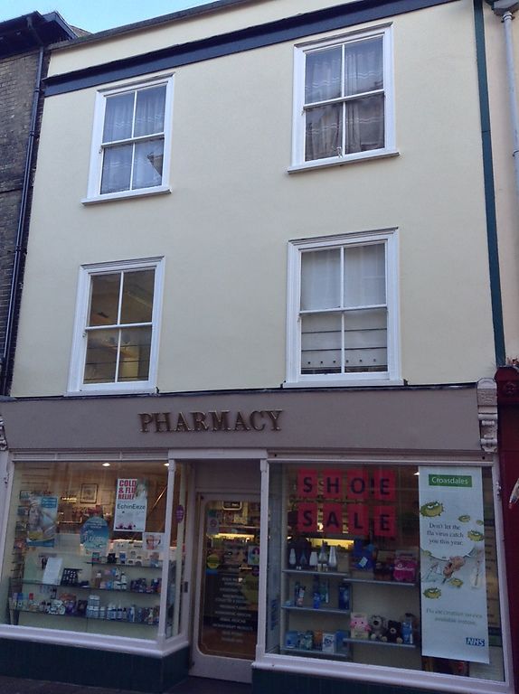
2 separate houses and shops, formerly Nos 1 and 2, now
combined as one shop. Early and mid C19. Part white brick and
slate roof, part timber framed and rendered. The corner
building is in white brick with a fully-hipped slate roof and
a wide modillion eaves soffit. A raised brick band runs
between the 1st and 2nd storey windows.
EXTERIOR: 3 storeys and cellars. 2 window range on each
facade, all sashes with single vertical glazing bars in deep
reveals. The 1st storey windows have flat gauged cement arches
with vermiculated keystones and on the Cornhill facade they
have diminished side lights.
The ground storey has a late C20 shop front in Regency style
with a corner entry. The former No.2 is timber-framed and
rendered with a flat roof behind a plain parapet and moulded
cornice. 2 window range, all sashes in flush cased frames with
a single vertical glazing bar. The ground storey has a C20
double shop front with a central entry.
INTERIOR: extensively modernised. The cellar is now part of
the retail area. No visible part of either building appears to
be prior to C19 in date.
Listing NGR: TL8527164317
External links are from the relevant listing authority and, where applicable, Wikidata. Wikidata IDs may be related buildings as well as this specific building. If you want to add or update a link, you will need to do so by editing the Wikidata entry.


Other nearby listed buildings
