Latitude: 54.3014 / 54°18'5"N
Longitude: -0.9521 / 0°57'7"W
OS Eastings: 468290
OS Northings: 490042
OS Grid: SE682900
Mapcode National: GBR PLSP.NT
Mapcode Global: WHF9M.B4VS
Plus Code: 9C6X822X+H5
Entry Name: Sundial Approximately 20 Metres South of Dial House
Listing Date: 14 July 1955
Last Amended: 24 June 1987
Grade: II
Source: Historic England
Source ID: 1149014
English Heritage Legacy ID: 328905
ID on this website: 101149014
Location: Gillamoor, North Yorkshire, YO62
County: North Yorkshire
District: Ryedale
Civil Parish: Gillamoor
Traditional County: Yorkshire
Lieutenancy Area (Ceremonial County): North Yorkshire
Church of England Parish: Kirkbymoorside All Saints
Church of England Diocese: York
Tagged with: Sundial
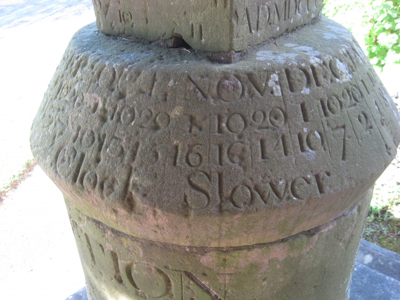
GILLAMOOR VILLAGE STREET SE 69 SE (north side) 6/70 Sundial approximately 20 metres south of Dial House (formerly listed as 14.7.55 Sundial to the north of The Chapel) - II Sundial. 1800 on north dial. By John Russell. Ashlar stone on roughly dressed stone base with cast-iron gnomons and brackets. Tall stepped plinth below the sundial consisting of a cylindrical pedestal supporting a cube surmounted by a sphere. Inscription around top of pedestal reads: "ERECTED BY SUBSCRIPTION". Sloped cap of cylinder carries a Time Equation table. Cube has east and west meridian dials carved on east and west faces, and north and south vertical direct dials to north and south faces. North face also inscribed with name and date: "J Russell Sculpit, August 27th, AD MDCCC". Horizontal dial to top. Sphere shows solar hours.
Listing NGR: SE6829090042
External links are from the relevant listing authority and, where applicable, Wikidata. Wikidata IDs may be related buildings as well as this specific building. If you want to add or update a link, you will need to do so by editing the Wikidata entry.


Other nearby listed buildings