Approximate Location Map
Large Map »
Latitude: 54.2542 / 54°15'15"N
Longitude: -1.1839 / 1°11'2"W
OS Eastings: 453264
OS Northings: 484590
OS Grid: SE532845
Mapcode National: GBR NM57.GR
Mapcode Global: WHD8K.SBDH
Plus Code: 9C6W7R38+MC
Entry Name: Kirby House
Listing Date: 14 March 1986
Grade: II
Source: Historic England
Source ID: 1149184
English Heritage Legacy ID: 328490
ID on this website: 101149184
Location: Cold Kirby, North Yorkshire, YO7
County: North Yorkshire
District: Ryedale
Civil Parish: Cold Kirby
Traditional County: Yorkshire
Lieutenancy Area (Ceremonial County): North Yorkshire
Church of England Parish: Upper Ryedale
Church of England Diocese: York
Tagged with: House
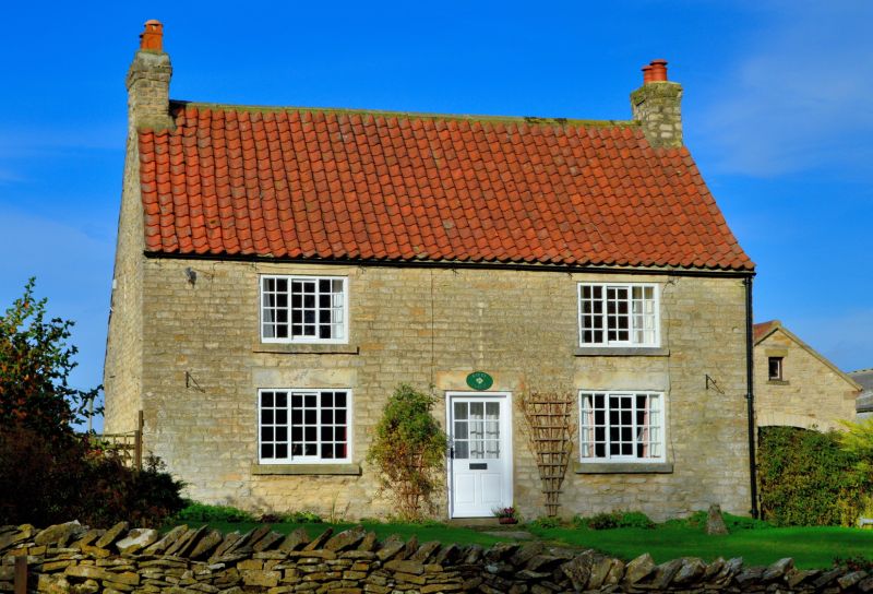
SE 58 SW COLD KIRBY MAIN STREET
(north side)
8/15 Kirby House
GV II
House. c1800 with C20 renovations. Limestone rubble, pantile roof. 2-cell
direct entry plan with continuous outshut to rear. 2 storeys, 2 first floor
windows. C20 half-glazed door. 3-light Yorkshire sashes beneath concrete
lintels throughout. Swept roof. End stacks. Included for group
considerations.
Listing NGR: SE5326484590
External links are from the relevant listing authority and, where applicable, Wikidata. Wikidata IDs may be related buildings as well as this specific building. If you want to add or update a link, you will need to do so by editing the Wikidata entry.


Other nearby listed buildings
