Latitude: 54.2176 / 54°13'3"N
Longitude: -1.2912 / 1°17'28"W
OS Eastings: 446315
OS Northings: 480438
OS Grid: SE463804
Mapcode National: GBR MMFN.7W
Mapcode Global: WHD8Q.48D2
Plus Code: 9C6W6P95+2G
Entry Name: Smithy Farmhouse and Former Smithy Adjoining
Listing Date: 16 January 1984
Grade: II
Source: Historic England
Source ID: 1151337
English Heritage Legacy ID: 333242
ID on this website: 101151337
Location: Bagby, North Yorkshire, YO7
County: North Yorkshire
District: Hambleton
Civil Parish: Bagby
Built-Up Area: Bagby
Traditional County: Yorkshire
Lieutenancy Area (Ceremonial County): North Yorkshire
Tagged with: Farmhouse
SE 48 SE BAGBY BAGBY LANE
3/3 (south side)
16.1.84
Smithy farmhouse and
former Smithy adjoining
II
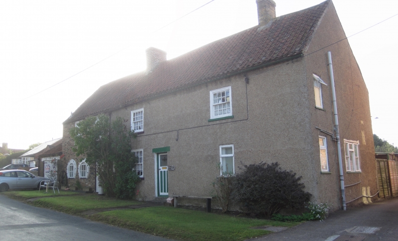
Farmhouse and attached former Smithy. C18-early C19. House rendered. Cogged brick
eaves. Smithy: reddish-brown brick, dentilled eaves. Pantile roofs. House: 2
storeys, 2 bays. Entrance to left of centre with c1930 door. Late C20 window to right
of entrance, otherwise 16 pane sashes in flush cases with cills. Smithy: single
storey. Carriage entrance to left, stable door with flat brick arch to centre and 2
horseshoe-shaped windows to right with round brick arches.
Listing NGR: SE4631580438
External links are from the relevant listing authority and, where applicable, Wikidata. Wikidata IDs may be related buildings as well as this specific building. If you want to add or update a link, you will need to do so by editing the Wikidata entry.


Other nearby listed buildings