Latitude: 53.5552 / 53°33'18"N
Longitude: -1.1273 / 1°7'38"W
OS Eastings: 457911
OS Northings: 406866
OS Grid: SE579068
Mapcode National: GBR NWKB.R8
Mapcode Global: WHDCW.NWDV
Plus Code: 9C5WHV4F+33
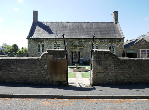
Entry Name: Wall Enclosing Yard to Front of Old Village School House
Listing Date: 23 March 1988
Grade: II
Source: Historic England
Source ID: 1151493
English Heritage Legacy ID: 334917
ID on this website: 101151493
Location: Arksey, Doncaster, South Yorkshire, DN5
County: Doncaster
Electoral Ward/Division: Bentley
Parish: Non Civil Parish
Built-Up Area: Bentley
Traditional County: Yorkshire
Lieutenancy Area (Ceremonial County): South Yorkshire
Church of England Parish: Arksey All Saints
Church of England Diocese: Sheffield
Tagged with: Wall
BENTLEY WITH ARKSEY HIGH STREET SE 50 NE (west side), Arksey 7/53 Wall enclosing yard to front of Old Village School House GV II Wall with gate openings. Late C17 or CIB. Rubble magnesian limestone with ashlar quoins and copings. L-shaped wall approximately l 1/2 metres in height enclosing east and south sides of yard to front of the Old Village School House (q.v.); the wall adjoins Cooke's Almshouses (q.v.) which bounds the north side of the yard; gateway opposite central entrance to school has taller piers to which the wall copings rise in a quadrant; short return of wall forms link to front-left corner of School House and has quoined gateway opening. Domed copings, partly removed as a result of vandalism to southern limb of wall. Included for group value.
Listing NGR: SE5791106866
External links are from the relevant listing authority and, where applicable, Wikidata. Wikidata IDs may be related buildings as well as this specific building. If you want to add or update a link, you will need to do so by editing the Wikidata entry.


Other nearby listed buildings