Approximate Location Map
Large Map »
Latitude: 51.7875 / 51°47'15"N
Longitude: -2.1936 / 2°11'37"W
OS Eastings: 386740
OS Northings: 209890
OS Grid: SO867098
Mapcode National: GBR 1M0.XY0
Mapcode Global: VH94R.XBPJ
Plus Code: 9C3VQRQ4+2G
Entry Name: The Manse with Gatepiers
Listing Date: 24 August 1990
Grade: II
Source: Historic England
Source ID: 1152271
English Heritage Legacy ID: 133270
ID on this website: 101152271
Location: Painswick, Stroud, Gloucestershire, GL6
County: Gloucestershire
District: Stroud
Civil Parish: Painswick
Built-Up Area: Painswick
Traditional County: Gloucestershire
Lieutenancy Area (Ceremonial County): Gloucestershire
Church of England Parish: Painswick St Mary the Virgin
Church of England Diocese: Gloucester
Tagged with: Architectural structure House Gatepost Wall
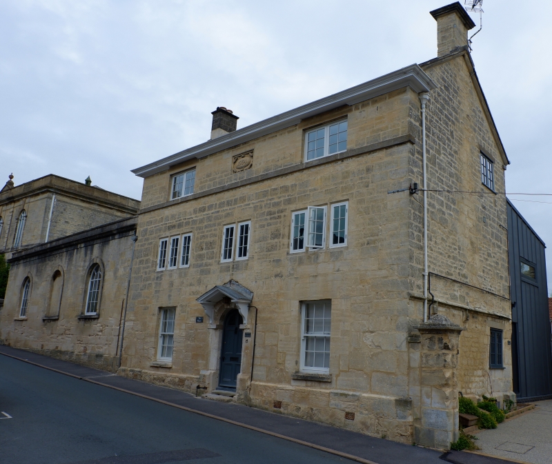
PAINSWICK GLOUCESTER STREET
SO 8609/8709 (part of)
(east side)
8/92 The Manse with gate piers
GV II
House, attached to Schoolroom (q.v.). Dated 1884, but this probably represents
a floor added to an earlier C19 structure. Large squared coursed limestone, low
pitched Welsh slate roof to coped verges with stone gable stacks with cappings.
Three storeys, 3 windows; at ground floor 2 C20 sashes; at first floor 3:2:3-
light stone chamfer-mullion casements with glazing bars, and at second floor two
2-light C20 casements flanking decorative date-stone. Central 6-panel door up 2
steps and to arched head with fanlight, with hollow-mould imposts and 3 key-
stones, open wood pediment on consoles. Plinth, plain sill string to second
floor, moulded wood deep projection eaves cornice. Return right has moulded
string at first floor level, and a blocked opening, also two C20 steel casements
To right and set back from street pair of wide-spaced stone square piers
to cavetto-mould capping and with domical crown; short length of boundary wall c
2.25 m high to right. Included for group valve.
Listing NGR: SO8674009890
External links are from the relevant listing authority and, where applicable, Wikidata. Wikidata IDs may be related buildings as well as this specific building. If you want to add or update a link, you will need to do so by editing the Wikidata entry.


Other nearby listed buildings
