Approximate Location Map
Large Map »
Latitude: 54.9477 / 54°56'51"N
Longitude: -1.9694 / 1°58'9"W
OS Eastings: 402058
OS Northings: 561453
OS Grid: NZ020614
Mapcode National: GBR GCP7.F5
Mapcode Global: WHB2F.QWDW
Plus Code: 9C6WW2XJ+36
Entry Name: Road Bridge over Railway
Listing Date: 18 June 1986
Grade: II
Source: Historic England
Source ID: 1154181
English Heritage Legacy ID: 240417
ID on this website: 101154181
Location: Broomhaugh, Northumberland, NE44
County: Northumberland
Civil Parish: Broomhaugh and Riding
Built-Up Area: Riding Mill
Traditional County: Northumberland
Lieutenancy Area (Ceremonial County): Northumberland
Church of England Parish: St James, Riding Mill
Church of England Diocese: Newcastle
Tagged with: Road bridge
BROOMHAUGH AND RIDING A 695 Broomhaugh
NZ 06 SW
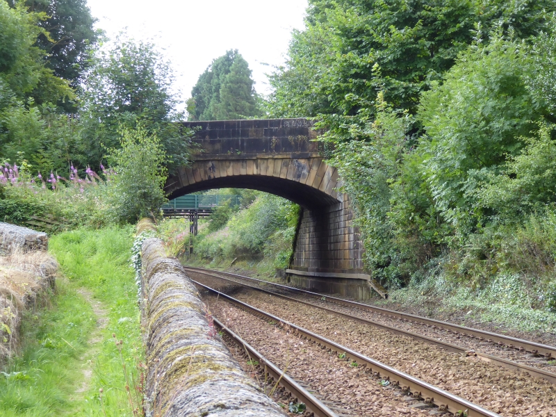
4/50 Road bridge over railway
II
Bridge, c.1832. Engineer Francis Giles. Dressed stone with channeled rustication
except for tooled-and-margined stone parapets. Segmental skew arch with band below
parapet; parapet flat-coped above chamfered set-back. Flat-coped wing walls with
double-stepped plinth slope down to low piers with flattened pyramidal caps.
Built for the Newcastle and Carlisle Railway.
Listing NGR: NZ0205861453
External links are from the relevant listing authority and, where applicable, Wikidata. Wikidata IDs may be related buildings as well as this specific building. If you want to add or update a link, you will need to do so by editing the Wikidata entry.


Other nearby listed buildings
