Approximate Location Map
Large Map »
Latitude: 51.406 / 51°24'21"N
Longitude: -1.152 / 1°9'7"W
OS Eastings: 459080
OS Northings: 167787
OS Grid: SU590677
Mapcode National: GBR 93B.X57
Mapcode Global: VHCZF.ZXBH
Plus Code: 9C3WCR4X+C6
Entry Name: Barn at Hall Place Farm
Listing Date: 10 November 1983
Grade: II
Source: Historic England
Source ID: 1155186
English Heritage Legacy ID: 39560
ID on this website: 101155186
Location: West Berkshire, RG7
County: West Berkshire
Civil Parish: Beenham
Traditional County: Berkshire
Lieutenancy Area (Ceremonial County): Berkshire
Church of England Parish: Beenham Valence
Church of England Diocese: Oxford
Tagged with: Barn
BEENHAM
SU 56NE
3/47 Barn At Hall Place
Farm
GV II
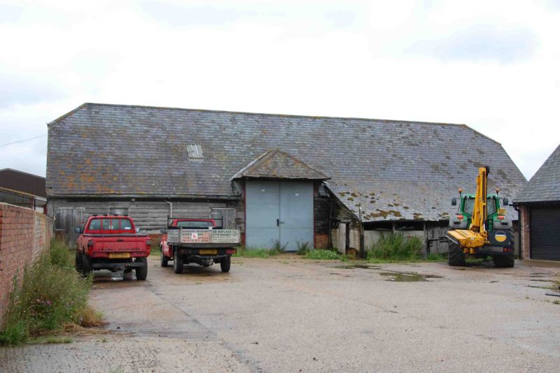
Barn at NGR SU 59156780. C16 with later alterations. Timber framed with brick
nogging; corrugated iron roof with hipped cart entrance to south in second bay from
right 5 bays. Queen strut trusses with transverse bracing, and wind braces.
Listing NGR: SU5908067787
External links are from the relevant listing authority and, where applicable, Wikidata. Wikidata IDs may be related buildings as well as this specific building. If you want to add or update a link, you will need to do so by editing the Wikidata entry.


Other nearby listed buildings
