Approximate Location Map
Large Map »
Latitude: 53.2257 / 53°13'32"N
Longitude: -1.0766 / 1°4'35"W
OS Eastings: 461746
OS Northings: 370252
OS Grid: SK617702
Mapcode National: GBR 9FP.QMQ
Mapcode Global: WHFGS.F5LX
Plus Code: 9C5W6WGF+79
Entry Name: Meden Cottage
Listing Date: 11 August 1961
Last Amended: 20 June 1986
Grade: II
Source: Historic England
Source ID: 1157078
English Heritage Legacy ID: 242242
ID on this website: 101157078
Location: Budby, Newark and Sherwood, Nottinghamshire, NG22
County: Nottinghamshire
District: Newark and Sherwood
Civil Parish: Perlethorpe cum Budby
Traditional County: Nottinghamshire
Lieutenancy Area (Ceremonial County): Nottinghamshire
Church of England Parish: Edwinstowe
Church of England Diocese: Southwell and Nottingham
Tagged with: Cottage
PERLETHORPE MAIN STREET
SK 67 SW
CUM BUDBY (formerly Carburton
Road) (north side)
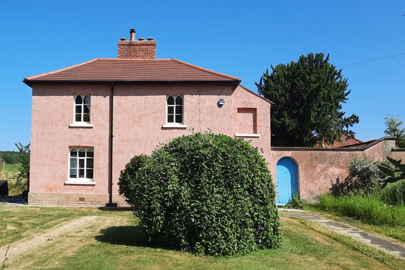
1/100 Meden Cottage
(formerly listed as
11.8.61 No.7)
G.V. II
Estate cottage. Early C19. Brick, rendered, with hipped and
lean-to concrete tile roofs. Stone plinth. Central ridge and
single rear roof stacks. 2 storeys, 3 unequal bays. Square plan
with lean-to wings. Windows are Gothick and plain casements.
South front has 2 casements and setback bay to right containing
round headed doorway. To its right, boundary wall with round
headed and segmental headed doorways. Above, to left, 2
casements and to right, blank opening with segmental head. East
side has blocked doorway and door. Above, 3 different casements.
To east, coped boundary wall and linked outbuilding, single
storey, 3 bays. West side has to left, lean-to with asbestos
cement roof. To its right, door flanked by single casements and
beyond, to right, blocked opening. Above, to right, blocked
opening. Rear elevation has, above, a gabled dormer. This
building is part of the complete Estate Village laid out by Earl
Manvers of Thoresby Park 1807-1812.
Listing NGR: SK6174670252
External links are from the relevant listing authority and, where applicable, Wikidata. Wikidata IDs may be related buildings as well as this specific building. If you want to add or update a link, you will need to do so by editing the Wikidata entry.


Other nearby listed buildings
