Approximate Location Map
Large Map »
Latitude: 50.0153 / 50°0'54"N
Longitude: -5.2592 / 5°15'33"W
OS Eastings: 166609
OS Northings: 17880
OS Grid: SW666178
Mapcode National: GBR Z2.J1LJ
Mapcode Global: VH13H.SWK5
Plus Code: 9C2P2P8R+48
Entry Name: Harbour Walls of Mullion Cove
Listing Date: 9 October 1984
Grade: II
Source: Historic England
Source ID: 1158181
English Heritage Legacy ID: 64669
ID on this website: 101158181
Location: Mullion Cove, Cornwall, TR12
County: Cornwall
Civil Parish: Mullion
Lieutenancy Area (Ceremonial County): Cornwall
Church of England Parish: Mullion
Church of England Diocese: Truro
Tagged with: Sea wall
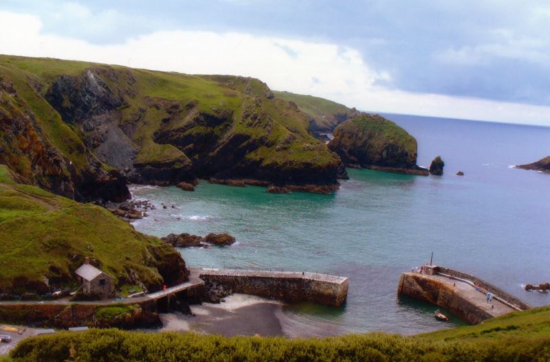
MULLION
SW 61 NE 5/89
MULLION COVE
Harbour Walls of Mullion Cove
II
Pair of harbour breakwaters. The North breakwater built in 1890-2 and the South breakwater 1895-7. Some parts probably earlier. Stone rubble south breakwater. North breakwater of snecked serpentine rubble with granite dressings and with granite setts to top surface. The two breakwaters project from cliffs and change direction at obtuse angles to enclose a small harbour that dries out at low tide. On the inside of the north breakwater are integral stone steps and over the outer seaward side a shelter wall, probably later, with a raised walkway on its inner side. The south breakwater is linked to a causeway at its landward end by two later bridges supported on steel joists. Railings are modern.
Mullion Cove was especially important for pilchard fishing, later superseded in the C19 by crab and lobster fishing. The harbour has remained largely unaltered.
This entry was subject to a Minor Amendment on 26 June 2017.
External links are from the relevant listing authority and, where applicable, Wikidata. Wikidata IDs may be related buildings as well as this specific building. If you want to add or update a link, you will need to do so by editing the Wikidata entry.


Other nearby listed buildings
