Approximate Location Map
Large Map »
Latitude: 51.5747 / 51°34'29"N
Longitude: -0.7725 / 0°46'21"W
OS Eastings: 485159
OS Northings: 186922
OS Grid: SU851869
Mapcode National: GBR D5W.9HH
Mapcode Global: VHDWB.KPG5
Plus Code: 9C3XH6FG+VX
Entry Name: Cedar Cottage
Listing Date: 31 January 1974
Grade: II
Source: Historic England
Source ID: 1159210
English Heritage Legacy ID: 46207
ID on this website: 101159210
Location: Marlow, Buckinghamshire, SL7
County: Buckinghamshire
Civil Parish: Marlow
Built-Up Area: Marlow
Traditional County: Buckinghamshire
Lieutenancy Area (Ceremonial County): Buckinghamshire
Church of England Parish: Great Marlow with Marlow Bottom, Little Marlow and Bisham
Church of England Diocese: Oxford
Tagged with: Cottage
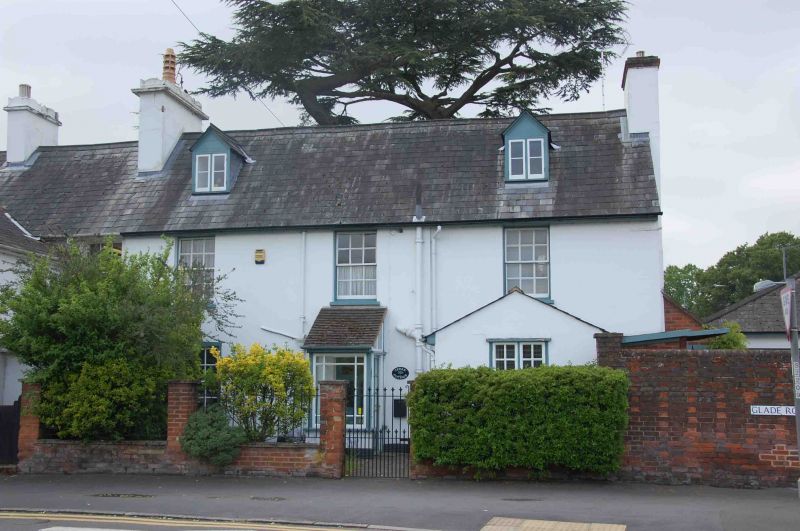
1.
1385
SU 8586
1/113
GLADE ROAD
Cedar Cottage
II
2.
Rear wing to the north comprises the part called Cedar Cottage and is probably
of earlier date. 4 windows and gabled dormers on the east side. Glazing bars.
Various later outbuildings and service additions.
Listing NGR: SU8515986922
External links are from the relevant listing authority and, where applicable, Wikidata. Wikidata IDs may be related buildings as well as this specific building. If you want to add or update a link, you will need to do so by editing the Wikidata entry.


Other nearby listed buildings
