Latitude: 50.2165 / 50°12'59"N
Longitude: -5.2421 / 5°14'31"W
OS Eastings: 168802
OS Northings: 40192
OS Grid: SW688401
Mapcode National: GBR Z3.FD2P
Mapcode Global: VH12K.3T1F
Plus Code: 9C2P6Q85+H4
Entry Name: Buddle Floor of Dressing Plant to West Basset Stamps on North Wheal Basset Sett, at SW 687 401
Listing Date: 12 September 1989
Grade: II
Source: Historic England
Source ID: 1160461
English Heritage Legacy ID: 66686
ID on this website: 101160461
Location: Carnkie, Cornwall, TR16
County: Cornwall
Civil Parish: Carn Brea
Traditional County: Cornwall
Lieutenancy Area (Ceremonial County): Cornwall
Church of England Parish: Redruth
Church of England Diocese: Truro
Tagged with: Architectural structure Buddle pit
CARN BREA CARNKIE
SW 64 SE
5/138 Buddle floor of dressing plant
to West Basset Stamps on North
Wheal Basset sett,
at SW 687 401
GV II
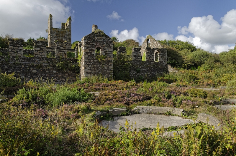
Buddle floor at tin ore dressing plant of former West Basset Mine; now derelict.
1874-5. Concrete floor channels and buddles, uncoursed rubble boundary walls.
Large rectangular floor enclosed by Vanner house on north-west side and
dilapidated rubble walls on the other sides; the floor has remains of 16 buddles -
shallow circular pits in which crushed tinstone mixed with water was deposited
and separated: 2 pairs of large convex buddles near the Vanner wall, each
approx. 6 metres in diameter and 0.5 metres deep, with a raised conical centre
on which the slurry was deposited; 2 rows of 5 approx. 4.5 metres in diameter
and 0.4 metres deep, mostly concave buddles in which the slurry was deposited
round the perimeter (both types formerly furnished with rotating sweeps); and 2
small dumb buddles close to the Vanner wall. History: constructed when West
Basset Mine took over northern half of former North Basset Mine. Principal
element of site which is probably now unique in Cornwall, Reference: Palmer and
Neaverson op.cit., pp.59-68.
Listing NGR: SW6870040100
External links are from the relevant listing authority and, where applicable, Wikidata. Wikidata IDs may be related buildings as well as this specific building. If you want to add or update a link, you will need to do so by editing the Wikidata entry.


Other nearby listed buildings