Approximate Location Map
Large Map »
Latitude: 50.3613 / 50°21'40"N
Longitude: -4.3148 / 4°18'53"W
OS Eastings: 235450
OS Northings: 53832
OS Grid: SX354538
Mapcode National: GBR NN.VMHK
Mapcode Global: FRA 18V2.W98
Plus Code: 9C2Q9M6P+G3
Entry Name: Harbour
Listing Date: 26 January 1987
Grade: II
Source: Historic England
Source ID: 1162071
English Heritage Legacy ID: 61965
ID on this website: 101162071
Location: Portwrinkle, Cornwall, PL11
County: Cornwall
Civil Parish: Sheviock
Traditional County: Cornwall
Lieutenancy Area (Ceremonial County): Cornwall
Church of England Parish: Sheviock
Church of England Diocese: Truro
Tagged with: Jetty
SX 35 SE SHEVIOCK PORTWRINKLE
5/313 Harbour
II
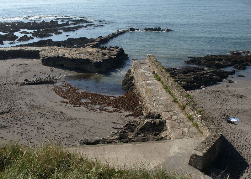
Jetty enclosing small basin of which the other side is formed by the
rocks. Probably C18. Mixed slatestone and metamorphic stone rubble;
built in stages with larger blocks of stone at base of wall. Square-
ended jetty, about 30 metres long, with a rubble wall about one metre
high along outer side. One wooden and 2 stone bollards of irregular
shape. Irregular slate paving.
the address and description shall be amended to read:
SX 35 SE SHEVIOCK PORTWRINKLE
5/313 Jetty to Harbour
II
Jetty. Probably c18. Mixed slatestone and metamorphic stone rubble;
built in stages with larger blocks of stone at base of wall. Square-
ended jetty, about 30 metres long, with a rubble wall about one metre
high along outer side. One wooden and 2 stone bollards of irregular
shape. Irregular slate paving.
-----------------------------------------------------------------------------------------
SX 35 SE SHEVIOCK PORTWRINKLE
5/313 Harbour
II
Jetty enclosing small basin of which the other side is formed by the rocks. Probably
C18. Mixed slatestone and metamorphic stone rubble; built in stages with larger
blocks of stone at base of wall. Square-ended jetty, about 30 metres long, with a
rubble wall about one metre high along outer side. One wooden and 2 stone bollards
of irregular shape. Irregular slate paving.
Listing NGR: SX3545053832
External links are from the relevant listing authority and, where applicable, Wikidata. Wikidata IDs may be related buildings as well as this specific building. If you want to add or update a link, you will need to do so by editing the Wikidata entry.


Other nearby listed buildings
