Approximate Location Map
Large Map »
Latitude: 50.2374 / 50°14'14"N
Longitude: -5.1825 / 5°10'57"W
OS Eastings: 173153
OS Northings: 42339
OS Grid: SW731423
Mapcode National: GBR Z6.13RX
Mapcode Global: FRA 081D.DSZ
Plus Code: 9C2P6RP8+XX
Entry Name: Former Church of All Saints
Listing Date: 28 September 1978
Last Amended: 12 September 1989
Grade: II
Source: Historic England
Source ID: 1162319
English Heritage Legacy ID: 66904
ID on this website: 101162319
Location: St Day, Cornwall, TR16
County: Cornwall
Civil Parish: St. Day
Built-Up Area: St Day
Traditional County: Cornwall
Lieutenancy Area (Ceremonial County): Cornwall
Church of England Parish: St Day
Church of England Diocese: Truro
Tagged with: Church building
ST DAY CHURCH STREET
SW 74 SW
(east side)
11/339
28.9.78
Former Church of All Saints
(formerly listed as ST DAY Old Parish Church)
GV
II
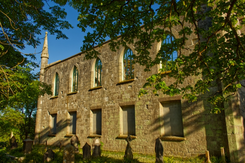
Church, now derelict. 1828, by C.Hutchins (Pevsner). Granite ashlar (roof
missing). Rectangular plan with nave and aisles forming a single vessel formerly
under a 3-span roof, and embracing a west tower, with a short apse at the east
end. Two storeys, with 3-stage tower. Gothick style, with deeply-chamfered 2-
and 4-centred openings, and tall corner pinnacles. The 3-stage tower has
weathered bands on 2 levels, carried across the aisles, and octagonal shafts at
the corners finished as tall pinnacles, a blocked 4-centred arched west doorway,
a 2-centred arched 3-light traceried window to the 2nd stage, a tall 3rd stage
with small 2-light belfry windows and gablets above these (flanked by the
pinnacles); a squat octagonal spire finished with a fleche. The end walls of the
aisles have similar but smaller doors, and 4-centred 3-light windows above. The
5-bay side walls have square-headed windows at ground floor, 2-centred windows
above. The east end has high-set 4-centred windows with stone tracery and
remains of stained glass. Interior destroyed.
Listing NGR: SW7315342339
External links are from the relevant listing authority and, where applicable, Wikidata. Wikidata IDs may be related buildings as well as this specific building. If you want to add or update a link, you will need to do so by editing the Wikidata entry.


Other nearby listed buildings
