Approximate Location Map
Large Map »
Latitude: 50.7914 / 50°47'29"N
Longitude: -3.4539 / 3°27'14"W
OS Eastings: 297617
OS Northings: 100101
OS Grid: SS976001
Mapcode National: GBR LK.ZGSK
Mapcode Global: FRA 37N0.270
Plus Code: 9C2RQGRW+HC
Entry Name: Former Stable Block 260 Metres East of Killerton House
Listing Date: 11 November 1952
Grade: II
Source: Historic England
Source ID: 1170665
English Heritage Legacy ID: 88411
ID on this website: 101170665
Location: Budlake, East Devon, EX5
County: Devon
District: East Devon
Civil Parish: Broad Clyst
Traditional County: Devon
Lieutenancy Area (Ceremonial County): Devon
Church of England Parish: Broadclyst St John the Baptist
Church of England Diocese: Exeter
Tagged with: Stable
SS 90 SE BROADCLYST KILLERTON PARK
2/98 Former Stable Block 260
- metres east of Killerton
11.11.52 House
- II
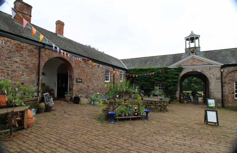
Former stables to Killerton House (now National Trust shop/ticket office). 1778 by
John Johnson. Coursed rubble volcanic trap with dressings of ashlar under slate
hipped roof. Quadrangular plan with opposed main entrances.
Front: 5 round-headed recessed bays with ashlar impost and keyblocks, the tympanum
of each bay with semi-circular window with radiating bars, the arcade otherwise
blind, stand to either side of a central, slightly projecting, round-headed entrance
under a pediment (the modillion cornice of which runs along the entire front)Central
axial octagonal clock turret clock, and bellcote with leaded tent cap, supported by
eight chamfered timber columns. Bell and gear intact, but perhaps missing weather
vane. Internal faces of main entrances also with pediments. A third entrance in
right-hand range is a simple round-headed arch with brick soffit. Blind arcade to
rear of front range, 4 bays. Internal face of rear range with 2 large round-headed
carriage doors to each side of central archway. Rear elevation quite plain. A 2-
storey cottage has been inserted into part of the right-hand range. The clock has a
very pretty cast iron frame, according to John Scott.
Listing NGR: SS9761700101
External links are from the relevant listing authority and, where applicable, Wikidata. Wikidata IDs may be related buildings as well as this specific building. If you want to add or update a link, you will need to do so by editing the Wikidata entry.


Other nearby listed buildings
