Latitude: 52.2675 / 52°16'3"N
Longitude: -2.068 / 2°4'4"W
OS Eastings: 395456
OS Northings: 263266
OS Grid: SO954632
Mapcode National: GBR 2GQ.S06
Mapcode Global: VH9ZZ.38LK
Plus Code: 9C4V7W9J+2R
Entry Name: Pumphouse Farmhouse
Listing Date: 20 January 1976
Grade: II
Source: Historic England
Source ID: 1179635
English Heritage Legacy ID: 147787
ID on this website: 101179635
Location: Mere Green, Wychavon, Worcestershire, WR9
County: Worcestershire
District: Wychavon
Civil Parish: Hanbury
Traditional County: Worcestershire
Lieutenancy Area (Ceremonial County): Worcestershire
Church of England Parish: Hanbury
Church of England Diocese: Worcester
Tagged with: Farmhouse
HANBURY CP PUMPHOUSE LANE (south side) SO 96 SE 4/111 (15/13) Pumphouse Farmhouse 20.1.76 GV II
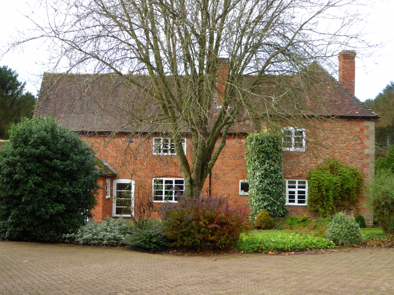
Farmhouse, now house. Early C17, altered and extended c1700, mid-C19 and mid-C20. Part timber-framed with painted brick infill, part brick (some handmade) with sandstone dressings; plain tiled roofs, hipped to north wing. Probably a former hall and cross-wing plan; cross-wing of two framed bays aligned north/south with two external chimneys to west side elevation, one of dressed sandstone with paired C19 diagonal brick shafts, the other all C19 brick; the hall has been replaced by a mainly C19 L-shaped addition, the main range of which runs parallel to the cross-wing and is of three bays with a two-bay east return and, at return junction, has a large sand- stone chimney with brick ridge stack. Two storeys, attic with dormer, and cellar. Framing: two large square panels from sill to girding-beam, three small square panels from girding-beam to wall-plate; collar and tie-beam truss at south gable end with two collars and five struts to lower collar, three to upper collar and concave-sided V-strut in apex; north gable end rebuilt in brick. South elevation: timber-framed gable end to left has a C20 glazed lean-to addition at ground-floor level, a 3-light first-floor casement and an attic light; C19 gable end to right has a ground-floor 2- light and a 3-light casement, the former with cambered head, the latter set within a blocked doorway with a pointed-arched hood mould; above is a 3- light casement with a cambered head and a brick stack. A C20 single-storey wing adjoins to right. North elevation of east return has sandstone quoins, a 3-light and a 4-light stone splayed-mullioned ground-floor window, two first-floor 3-light casements with cambered heads, a hipped roof dormer with a 3-light casement, and to the right a large blocked doorway with sandstone quoins and lintel and an inserted C20 door. Interior: the timber-framed wing has a close-studded east side elevation with a 5-light wood-mullioned window to the south bay. The house was once part of the Vernon Estate.
Listing NGR: SO9545663266
External links are from the relevant listing authority and, where applicable, Wikidata. Wikidata IDs may be related buildings as well as this specific building. If you want to add or update a link, you will need to do so by editing the Wikidata entry.


Other nearby listed buildings