Latitude: 53.6704 / 53°40'13"N
Longitude: -1.5725 / 1°34'21"W
OS Eastings: 428339
OS Northings: 419407
OS Grid: SE283194
Mapcode National: GBR KVG0.B0
Mapcode Global: WHCB4.T0CJ
Plus Code: 9C5WMCCG+5X
Entry Name: Christ Church
Listing Date: 6 May 1988
Grade: II
Source: Historic England
Source ID: 1184136
English Heritage Legacy ID: 342520
ID on this website: 101184136
Location: Christ Church, South Ossett, Wakefield, West Yorkshire, WF5
County: Wakefield
Electoral Ward/Division: Horbury and South Ossett
Parish: Non Civil Parish
Built-Up Area: Ossett
Traditional County: Yorkshire
Lieutenancy Area (Ceremonial County): West Yorkshire
Church of England Parish: South Ossett Christ Church
Church of England Diocese: Leeds
Tagged with: Church building
SE21NE
6/27
OSSETT
HORBURY ROAD
(north side), South Ossett
Christ Church
II
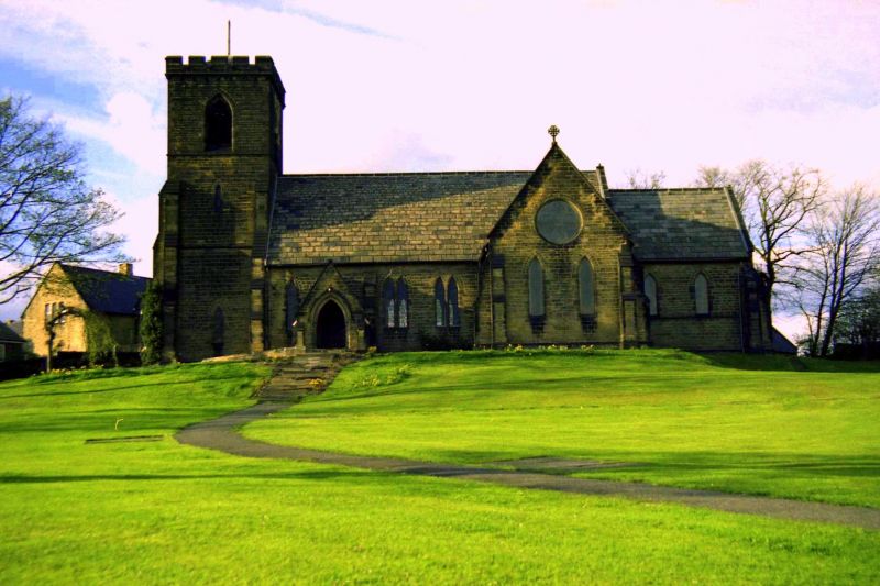
Church built 1851 to designs by Mallinson and Healey. Tooled squared stone with ashlar dressings. Welsh slate roof. Cruciform plan with west tower, 3+-bay nave with south porch, north and south transepts, and a 2-bay chancel, with later organ chamber to north-east, in keeping. Angle buttresses. The square tower has reducing buttresses, a stair tower to north, 2-light, louvred, bell-chamber openings and a low pyramidal roof behind a bracketed, crenellated parapet. Double-chamfered lancet windows with cusped heads. 3-light north transept window, 3-light east window with 3 quatrefoils in head, south transept has 2 lancets and a wheel in the apex containing 4 trefoils.
Interior: 6 arch-braced roof trusses to nave with reverse curved struts springing from the centre of the tie-beam. Scissor-braced transept roofs. Panelled chancel roof. Stained glass to east window and south transept. Straight-backed pews to nave only. Small west gallery with ancilliary accommodation beneath gallery and under tower.
Listing NGR: SE 28339 19407
External links are from the relevant listing authority and, where applicable, Wikidata. Wikidata IDs may be related buildings as well as this specific building. If you want to add or update a link, you will need to do so by editing the Wikidata entry.


Other nearby listed buildings