Latitude: 50.5168 / 50°31'0"N
Longitude: -3.7529 / 3°45'10"W
OS Eastings: 275821
OS Northings: 70021
OS Grid: SX758700
Mapcode National: GBR QJ.1TVB
Mapcode Global: FRA 370P.RQ5
Plus Code: 9C2RG68W+PR
Entry Name: 65, 65 1/2, 67 and 67A, East Street
Listing Date: 7 August 1951
Last Amended: 1 September 1992
Grade: II
Source: Historic England
Source ID: 1187272
English Heritage Legacy ID: 376046
ID on this website: 101187272
Location: Ashburton, Teignbridge, Devon, TQ13
County: Devon
District: Teignbridge
Civil Parish: Ashburton
Built-Up Area: Ashburton
Traditional County: Devon
Lieutenancy Area (Ceremonial County): Devon
Church of England Parish: Ashburton St Andrew
Church of England Diocese: Exeter
Tagged with: Building
ASHBURTON
SX7570 EAST STREET 849-1/9/68 (North side) 07/08/51 Nos.65, 65 1/2, 67, 67A (Formerly Listed as: EAST STREET (North side) Nos.65, 67 AND 67A)
GV II
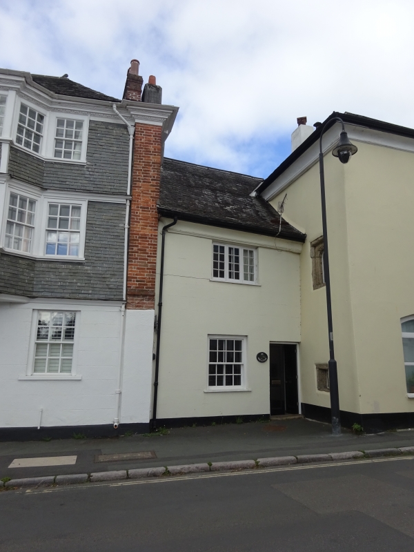
Former inn, now divided into 4 houses. Late medieval, the major right-hand portion (No 65 1/2 - No 67A), rebuilt early or mid C16. Solid rendered walls (stone rubble and cob). Slated roof. 4 rendered chimneys. Much altered, but No 65 1/2 appears to be a former projecting entrance porch with room adjoining, off-centre to left. Stair turret with canted sides at right-hand end. Cart entrance, with rooms over, at rear, opening off Roborough Lane. 2 storeys. 5 windows wide. No 65 has panelled double doors; 8-paned sash window to left. Upper storey has 3-light wood casement window with glazing bars. No 65 1/2 has late C20 panelled door; large segmentel-headed C20 window to left; 8-paned sash window in upper storey. Left side wall has two C16 single-light windows: small square-headed one in ground storey, taller round-headed one above. Right side wall has similar square-headed window set between storeys. Nos 67-67A have 5-panelled C19 door, flanked by 8-paned sash window; 2 matching windows in upper storey with a 6-paned sash window at a lower level in the centre. Attached to the right-hand end is a conduit head, which is separately listed. Above it is a small round-headed stair window; 3 round-headed lights (1 now blocked). Right side wall to Roborough Lane has small blocked round-arched window to left of upper storey. To right of it, a partly blocked square-headed window with remains of hood-mould. Cart entrance has segmental arch and double plank doors. Two 6-paned sash windows above. The whole front has a coved eaves-cornice, returning on to the side of the stair turret. Interior: 1983 report says No 65 (the medieval part) has 3 original trusses with clasped purlins, comparable to those formerly at No 33 North Street (demolished 1970). W gable and centre trusses have sole-plates and ashlar-posts; purlins clasped between collar and principal held in position by an upright timber halved to both collar and principal. Timber darkened, but not certainly smoke-blackened. East truss closed with clean wattle-and-daub. Remainder of building re-roofed C17 or C18. A shouldered-head door frame survives in the roof space. c.late C16 or earlier C17 painted plaster survives on 1 wall of first floor right-hand room. No 67 has in rear left-hand ground floor room a beam, parallel to street, with hollow and half-round mouldings; at left-hand end the moulding turns down to form the head of a stud. On 1st floor, to right, a stud-and-panel partition parallel with street; studs have ogee and half-round mouldings at front, plain chamfers at rear. Adjoining it (probably re-set) a shouldered-head door frame. Adjoining stairs, linenfold panelling, also probably re-set. No 67A has C18 ground floor chimneypiece, eared architrave with keyblock and moulded cornice, cupboard with shaped shelves. 3-panelled ovolo-moulded door and another upstairs. Against right gable wall on ground floor a beam with ogee and quarter-round mouldings. The building is believed to have been The Spread Eagle Inn. (1971-: 181-6).
Listing NGR: SX7582170021
External links are from the relevant listing authority and, where applicable, Wikidata. Wikidata IDs may be related buildings as well as this specific building. If you want to add or update a link, you will need to do so by editing the Wikidata entry.


Other nearby listed buildings