Latitude: 50.1663 / 50°9'58"N
Longitude: -5.1082 / 5°6'29"W
OS Eastings: 178120
OS Northings: 34205
OS Grid: SW781342
Mapcode National: GBR ZB.4RB7
Mapcode Global: FRA 085L.5QN
Plus Code: 9C2P5V8R+GP
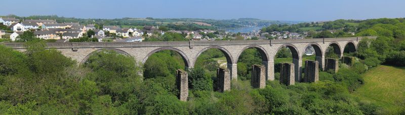
Entry Name: Penryn South West Railway Viaduct
Listing Date: 22 September 1971
Grade: II
Source: Historic England
Source ID: 1187647
English Heritage Legacy ID: 365808
ID on this website: 101187647
Location: Penryn, Cornwall, TR10
County: Cornwall
Civil Parish: Penryn
Built-Up Area: Penryn
Traditional County: Cornwall
Lieutenancy Area (Ceremonial County): Cornwall
Church of England Parish: St Gluvias
Church of England Diocese: Truro
Tagged with: Railway viaduct
PENRYN
SW7834SW NEW STREET, Penryn (South-West) 580-1/5/214 Railway Viaduct 22/09/71
GV II
Railway viaduct. Early C20. Rock-faced granite; round brick arches; concrete core and concrete parapet. 11 bays with tapered piers; impost strings; corbelled refuges at alternate bays and corbels for timber centering supports.
Listing NGR: SW7812034205
External links are from the relevant listing authority and, where applicable, Wikidata. Wikidata IDs may be related buildings as well as this specific building. If you want to add or update a link, you will need to do so by editing the Wikidata entry.


Other nearby listed buildings