Approximate Location Map
Large Map »
Latitude: 54.2151 / 54°12'54"N
Longitude: -1.2565 / 1°15'23"W
OS Eastings: 448582
OS Northings: 480190
OS Grid: SE485801
Mapcode National: GBR MMNP.RR
Mapcode Global: WHD8Q.N9WY
Plus Code: 9C6W6P8V+39
Entry Name: Outbuilding Approximately 10 Metres to East of Low Osgodby Grange
Listing Date: 20 December 1988
Grade: II
Source: Historic England
Source ID: 1190883
English Heritage Legacy ID: 332910
ID on this website: 101190883
Location: North Yorkshire, YO7
County: North Yorkshire
District: Hambleton
Civil Parish: Thirkleby High and Low with Osgodby
Traditional County: Yorkshire
Lieutenancy Area (Ceremonial County): North Yorkshire
Tagged with: Appendage
THIRKLEBY HIGH AND LOW -
SE 48 SE WITH OSGODBY
1/52 Outbuilding approximately
10 metres to east of Low
Osgodby Grange
GV II
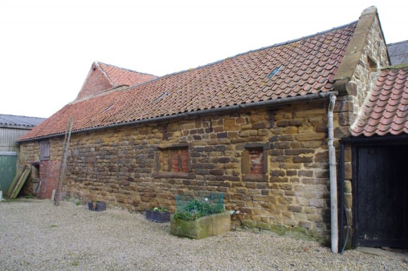
Outbuilding. C17, later converted to stables. Coursed squared stone, pantile roof.
Single storey with loft, 3 bays. Quoins. West side, from left: stable door with
brick walling to its right, shuttered opening above and quoins on right which
possibly indicates a former, inserted, cart-entry (on the left); bay 2 has part
of a window lintel at mid-height; bay 3 has a blocked 3-light and a blocked 1-light
chamfered mullion window and ends of 2 iron tie-rods. Eaves band. Shaped kneeler
and ashlar coping to right gable. Rear: a stable door, window and door, all C20;
the ends of the tie-rods at eaves; eaves band. Right gable has a blocked 2-light
chamfered mullion window, partly blocked by adjoining range, this and the rear
addition not being of special interest. Interior of less interest, the roof trusses
being C20.
Listing NGR: SE4858280190
External links are from the relevant listing authority and, where applicable, Wikidata. Wikidata IDs may be related buildings as well as this specific building. If you want to add or update a link, you will need to do so by editing the Wikidata entry.


Other nearby listed buildings
