Latitude: 52.93 / 52°55'47"N
Longitude: -0.632 / 0°37'55"W
OS Eastings: 492053
OS Northings: 337830
OS Grid: SK920378
Mapcode National: GBR DPY.91Q
Mapcode Global: WHGKH.8M94
Plus Code: 9C4XW9H9+X6
Entry Name: The Old School
Listing Date: 21 September 1979
Last Amended: 14 November 1994
Grade: II
Source: Historic England
Source ID: 1194838
English Heritage Legacy ID: 382904
ID on this website: 101194838
Location: Manthorpe, South Kesteven, Lincolnshire, NG31
County: Lincolnshire
District: South Kesteven
Civil Parish: Belton and Manthorpe
Built-Up Area: Grantham
Traditional County: Lincolnshire
Lieutenancy Area (Ceremonial County): Lincolnshire
Church of England Parish: Grantham Manthorpe
Church of England Diocese: Lincoln
Tagged with: School building
BELTON & MANTHORPE
SK9237 HIGH ROAD, Manthorpe
1315-0/11/127 (South East side)
21/09/79 The Old School
(Formerly Listed as:
HIGH ROAD, Manthorpe
Former Village School)
II
Also known as: School House HIGH ROAD Manthorpe.
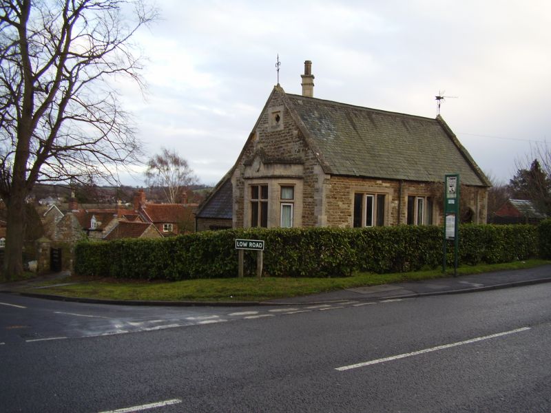
Former school, now a house. Dated 1865, with late C20
additions and alterations. Coursed squared stone with ashlar
dressings and stone slate roof. Large external rear wall stack
with square stone flue set diagonally. Tudor Revival style.
Plinth, quoins, coped gables with kneelers and iron finials.
Single storey; 3 bays. L-plan. To right, a 4-centred arched
board door with a datestone in a panel above it. To left, 2
reglazed 3-light windows with chamfered stone mullions and
surrounds. Left gable has a canted stone bay window with a
gabled parapet and central stone mullioned cross casement.
Above it, a quatrefoil in a sunken panel. Rear wing has late
C20 fenestration.
An educational building provided for workers on the Belton
estate by the Brownlow family of Belton House.
(The Buildings of England: Pevsner N, Harris J & antram N:
Lincolnshire: London: 1964-1989: 550).
Listing NGR: SK9203437745
External links are from the relevant listing authority and, where applicable, Wikidata. Wikidata IDs may be related buildings as well as this specific building. If you want to add or update a link, you will need to do so by editing the Wikidata entry.


Other nearby listed buildings