Latitude: 51.5447 / 51°32'41"N
Longitude: -0.0976 / 0°5'51"W
OS Eastings: 532018
OS Northings: 184586
OS Grid: TQ320845
Mapcode National: GBR Q0.7F
Mapcode Global: VHGQT.8F8N
Plus Code: 9C3XGWV2+VX
Entry Name: Canonbury Tavern
Listing Date: 30 September 1994
Grade: II
Source: Historic England
Source ID: 1195508
English Heritage Legacy ID: 368660
Also known as: The Canonbury Tavern
ID on this website: 101195508
Location: Canonbury, Islington, London, N1
County: London
District: Islington
Electoral Ward/Division: Canonbury
Parish: Non Civil Parish
Built-Up Area: Islington
Traditional County: Middlesex
Lieutenancy Area (Ceremonial County): Greater London
Church of England Parish: Mildmay Grove St Jude
Church of England Diocese: London
Tagged with: Pub
ISLINGTON
TQ3284NW CANONBURY PLACE 635-1/47/169 (North side) No.21 Canonbury Tavern
GV II
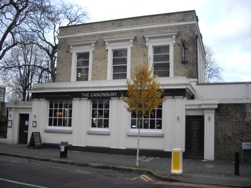
Public house. c.1846. Grey brick and stucco, roof not visible. Two storeys. The principal facade to Canonbury Place is of three bays, the ground floor having a single-storey projection running the full width of the facade and flanked by entrance wings with entablatures; the projection, possibly an addition, is faced with stucco and has flat-arched windows flanked by paired pilasters, fascia, cornice and parapet. First-floor windows are flat-arched with stucco architraves and cornices on consoles above. Simple moulded cornice of stucco; parapet. Single-storey wing to the east. Cast-iron railings to garden with fleur-de-lys and pineapple finials. (Eric Willatts: Streets with a story. The book of Islington: London: 1986-).
Listing NGR: TQ3201884586
External links are from the relevant listing authority and, where applicable, Wikidata. Wikidata IDs may be related buildings as well as this specific building. If you want to add or update a link, you will need to do so by editing the Wikidata entry.


Other nearby listed buildings