Approximate Location Map
Large Map »
Latitude: 51.5443 / 51°32'39"N
Longitude: -0.0972 / 0°5'49"W
OS Eastings: 532047
OS Northings: 184536
OS Grid: TQ320845
Mapcode National: GBR Q0.BL
Mapcode Global: VHGQT.8GH0
Plus Code: 9C3XGWV3+P4
Entry Name: 14, Alwyne Place
Listing Date: 20 September 1954
Last Amended: 30 September 1994
Grade: II
Source: Historic England
Source ID: 1298140
English Heritage Legacy ID: 368493
ID on this website: 101298140
Location: Canonbury, Islington, London, N1
County: London
District: Islington
Electoral Ward/Division: Canonbury
Parish: Non Civil Parish
Built-Up Area: Islington
Traditional County: Middlesex
Lieutenancy Area (Ceremonial County): Greater London
Church of England Parish: St Stephen Canonbury
Church of England Diocese: London
Tagged with: Building
ISLINGTON
TQ3284NW ALWYNE PLACE
635-1/47/7 (East side)
20/09/54 No.14
(Formerly Listed as:
ALWYNE PLACE
Nos.14, 14A
The Manor)
GV II
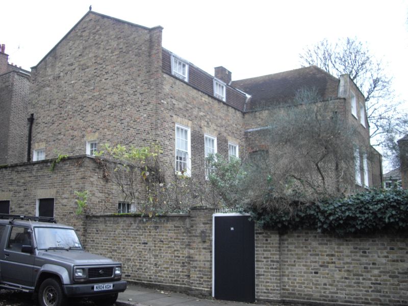
Single house. Early and late C18 or early C19, much reworked.
Purplish and yellow brick set in Flemish bond, roof of C20
tiles. Three storeys; two gabled wings forming a T in plan,
one at the rear running parallel to the street, one to the
front with gable to the street. Entrance in front wing, facing
south, Ionic columns with entablature and pediment; three bays
of flat-arched windows with gauged brick heads, the
ground-floor sashes recessed, those to first floor set flush,
presumably in C20. Parapet; C20 mansard roof with dormers. The
rear wing is of three storeys, and two bays to south,
flat-arched windows with gauged brick heads; truncated gable
fronting a half-hipped roof. On north side of front wing, two
first-floor windows with cambered arches of red gauged brick.
The immediate street front consists of a single-storey
parapeted screen wall, with three blank windows and a C20
reproduction doorcase. Between the main part of the house and
no 16 is a wing, part of no. 14, whose ridge runs parallel
with the street, presumably three storeys high, with brickwork
of C18 or earlier date; between that and the street, a lower,
two-storey parapeted wing of late C18 or early C19 date in
yellow brick, much reworked. Garden front, not inspected.
Listing NGR: TQ3204784536
External links are from the relevant listing authority and, where applicable, Wikidata. Wikidata IDs may be related buildings as well as this specific building. If you want to add or update a link, you will need to do so by editing the Wikidata entry.


Other nearby listed buildings
