Approximate Location Map
Large Map »
Latitude: 53.7496 / 53°44'58"N
Longitude: -3.0351 / 3°2'6"W
OS Eastings: 331836
OS Northings: 428630
OS Grid: SD318286
Mapcode National: GBR 7T72.PM
Mapcode Global: WH85N.B0YV
Plus Code: 9C5RPXX7+RW
Entry Name: St Anne's Pier
Listing Date: 21 September 1973
Grade: II
Source: Historic England
Source ID: 1196341
English Heritage Legacy ID: 385317
ID on this website: 101196341
Location: Lytham St Anne's, Fylde, Lancashire, FY8
County: Lancashire
District: Fylde
Civil Parish: Saint Anne's on the Sea
Built-Up Area: Lytham St Anne's
Traditional County: Lancashire
Lieutenancy Area (Ceremonial County): Lancashire
Church of England Parish: St Annes on Sea St Anne (Heyhouses)
Church of England Diocese: Blackburn
Tagged with: Pier
LYTHAM ST ANNES
SD32NW SOUTH PROMENADE, St Anne's
621-1/2/114 (South West side)
21/09/73 St Anne's Pier
GV II
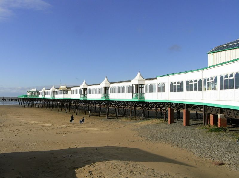
Pier. 1885, with additions of 1904 and 1910; altered, and now
reduced to about half its original length following a fire
c.1978.
Cast-iron with wooden deck; shelters and pavilions of
cast-iron, wood and glass with metal-clad roofs; entrance
pavilion (1910) of red brick with some mock half-timbering and
red tiled roof.
The main structure consists of 4 parallel rows of cast-iron
columns embedded in the beach (an inner and an outer row on
each side, inclined inwards), the inner rows linked by
segmentally-arched girders with geometrical open work in the
spandrels and the outer rows now by C20 latticed girders (and
the whole structure now re-inforced by similar C20 girders
running close to the original inner girders).
The wooden deck is now enclosed along about three-quarters of
its remaining length by a modern amusement arcade
incorporating an original pair of cantilevered shelters
(altered as kiosks) about halfway along. The open deck beyond,
which is protected by attractive geometrical cast-iron
railings, widens to form 2 hexagonal platforms: the inner
carrying a pair of lozenge-shaped pavilions (restoration in
progress 1991), and the outer a pair of cantilevered shelters.
All these shelters and pavilions have panelled and glazed
screen walls and emphatically-swept roofs with tall metal
finials.
The entrance pavilion is in vernacular-revival style,
symmetrical, with a tall 2-storey centre and lower 2-storey
side wings; the centre has half-timbering at 1st floor, a
projected gabled bay with an oriel and a jettied gable, and an
octagonal lantern on the roof; the wings have hipped roofs and
half-dormers with shaped gables.
The ground floor is now covered by a modern loggia run out
with shops at each end.
The item is the principal element in an associated group of
promenade structures including bandstand (q.v.), lifeboat
monument (q.v.), octagonal pavilion (q.v.) and two shelters
(q.v.).
Listing NGR: SD3183628630
External links are from the relevant listing authority and, where applicable, Wikidata. Wikidata IDs may be related buildings as well as this specific building. If you want to add or update a link, you will need to do so by editing the Wikidata entry.


Other nearby listed buildings
