Latitude: 54.888 / 54°53'16"N
Longitude: -2.9262 / 2°55'34"W
OS Eastings: 340684
OS Northings: 555199
OS Grid: NY406551
Mapcode National: GBR 8C0X.8L
Mapcode Global: WH803.0DVM
Plus Code: 9C6VV3QF+6G
Entry Name: 5-61, St Nicholas Street
Listing Date: 22 March 1974
Grade: II
Source: Historic England
Source ID: 1196911
English Heritage Legacy ID: 386853
ID on this website: 101196911
Location: Carlisle, Cumberland, Cumbria, CA1
County: Cumberland
District: Carlisle
Parish: Non Civil Parish
Built-Up Area: Carlisle
Traditional County: Cumberland
Lieutenancy Area (Ceremonial County): Cumbria
Church of England Parish: Carlisle St John the Evangelist
Church of England Diocese: Carlisle
Tagged with: Building
CARLISLE
NY4055 ST NICHOLAS STREET 671-1/11/256 (East side) 22/03/74 Nos.5-61 (Odd)
GV II
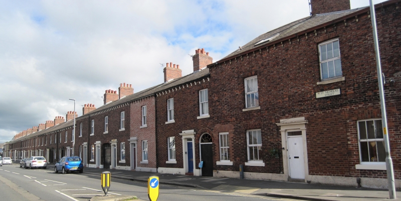
Terrace of 28 houses. 1840s and early 1850s. Flemish bond brickwork with light headers (some houses rendered) on chamfered plinth (all dressings of painted stone) and stone-bracketed metal gutter. Common Welsh slate roof, except Nos 51-61 of higher roof line, hipped on corner; shared ridge brick chimney stacks. 2 storeys, some of single bay, others of 2 bays; double-depth plan (some may have been back-to-back and knocked through). Houses are paired with left and right doors (many are C20) in original pilastered surrounds. Each pair of houses is separated from the next by a round-arched through-passageway to court behind, with plank door and occasionally a radial fanlight (unglazed). Some sash windows, but mostly C20 casements in brick reveals with stone sills, flat brick arches and shutter hinge blocks; the 2-bay houses have a window over the archways. Nos 5-17 have windows in stone architraves; No.21 has C20 shop window inserted; No.25 also had a C20 shop front, but replacement sash window fitted 1990. Between Nos 53 and 55 the archway is large with double doors. The corner property No.61 was the White Ox Inn, but its ground-floor shop window has been blocked and a C20 sash window inserted; on the rounded angle is the former inn sign in the form of a large rectangular stucco panel surmounted by an ox (now with 1989 mural of a pastoral scene, the ox converted to a cow; on the OS map this now appears as part of No.11 Woodrouffe Terrace). INTERIORS not inspected. This does not appear on the 1842 Map of Carlisle, but does appear on the 1848 Tithe Map. Carlisle Journal (1877) refers to the sale of the well-accustomed beer house, the White Ox, on St Nicholas Street. (Carlisle Journal: 16 February 1877).
External links are from the relevant listing authority and, where applicable, Wikidata. Wikidata IDs may be related buildings as well as this specific building. If you want to add or update a link, you will need to do so by editing the Wikidata entry.


Other nearby listed buildings